We were up early this morning. It was going to be a long drive to Las Vegas (325 miles) and the temperatures were starting out in the morning near freezing but climbing in the afternoon to over 100 Degrees. There were a few big hills on the route and David wanted to be over those early while the temperatures were still cool. We were on the road before 9am. We pulled into Las Vegas RV Resort ($21 per night with monthly discount) around 3pm local time. Were here for David’s work for the next 5 months (No sane person would come to Vegas in the summer for fun!). Temperatures this week are going to set records over 115 degrees. We are missing our cooler high altitude weather! Were planning to do short trips to state and federal parks in the area when David’s schedule allows it. We will post pictures when we take those trips.
Sunday, June 13, 2021
10 June 2021 Rush to Loa
We were surprised today when a RV Park employee came to our door and asked why we were not leaving. We thought we were staying in Torrey until 11 June. But apparently there was a mix up in the reservations and we only had a site until 0 June. Fortunately, the office found us a site down the road in Loa Utah. So we quickly got the Wanderer packed up and we got on the road to Loa. It is only a 20 mile drive to Loa and we arrived at the Fremont RV Park (37.50 with Good Sam) in Loa in early afternoon. The park is only a couple of year old and is really a big gravel lot. They only had one site left and it was really intended for tents, so the electric and water were on the wrong side of the rig and there was no sewer hook up. But it was a home for the night.
9 June 2021 Cathedral Valley
David had another day off work, so we decided to explore the northern portion of Capitol Reef NP. We took Hartnet Road just outside the east side of the park and into the northern desert area. We traversed 28 miles of rough dirt road across BLM, private and NP property, to reach the cliff overlooking Cathedral Valley with its iconic Cathedral Buttes. Part of the road traverses a layer formed from ash from the eruption of Boulder Mountain that we now identify with Petrified Wood. So we stopped and looked around and sure enough, we found petrified wood in the rocks along side the road. It is all over. Cool! The road traverses several different ecological layers, which made the drive interesting and the scenery spectacular. We ate lunch at the overlook for Cathedral Valley taking in the view. We made our way down the switchbacks of Cathedral Valley Road to get closer to the Cathedral Buttes. They are beautiful. But the cliffs lining the sides of the valley are also spectacular and reminded us of the Flying Buttresses you see on medieval churches (like Notre Dam). We exited the valley to the north on Baker Ranch Road and followed a winding passage across several dirt roads into Fish Lake National Forest. We climbed up to 9600 feet (Some of the road grades were over 20%) before descending to Utah 72, which we followed back to Utah 24. The Behemoth is covered in dust once again but it did a great job on 60 miles of dirt and rock roads.
 |
| Chimney Rock in Capitol Reef NP |
 |
| A old drill rig on Hartnet Road |
 |
| Door on the old drill rig |
 |
| High Desert in Capitol Reef NP |
 |
| Trail into the desert |
 |
| The Cathedrals in Cathedral Valley |
 |
| Two of the Cathedrals |
 |
| Cathedral Valley |
 |
| Looking into Northern Capitol Reef from Fish Lake National Forest |
Thursday, June 10, 2021
8 June 2021 Canyons and Petrified Wood
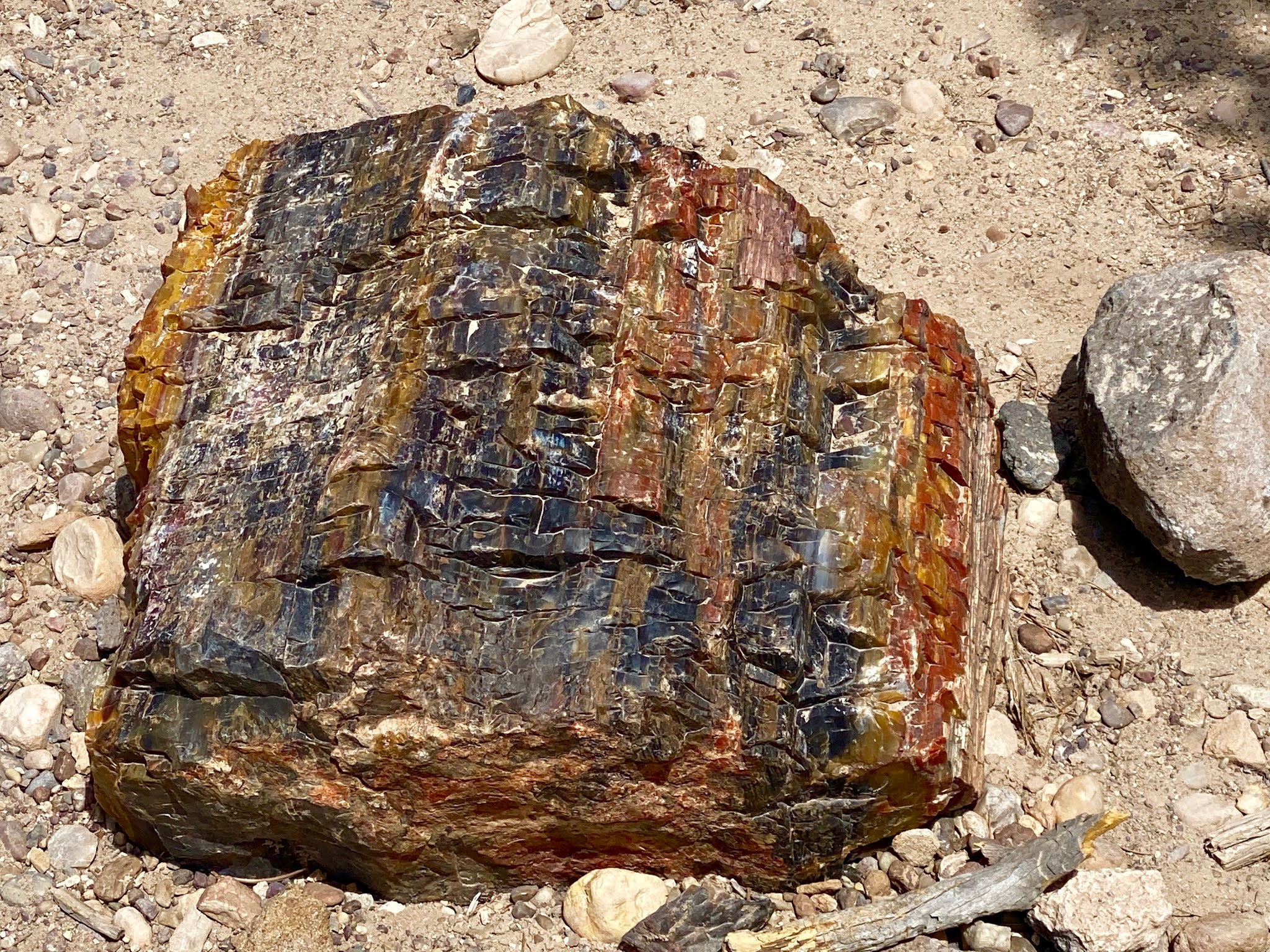
David was given a day off with all the telecons canceled. So we wanted to take advantage of the time. We researched some of the slot canyons in Capitol Reef NP, and picked one off the Notom Road on the east side of Capitol Reef NP. The trails start on BLM land and then take you into canyons in the Reef in the NP. We also were interested in taking the Burr Trail road, which climbs a steep series of switchbacks in the NP before descending through the Circle Cliff area of Grand Staircase Escalante NM. We arrived at the trailhead for Sheets Gulch around 9:30 and the temperatures were in the low 70s. The trail follows the wash up hill at a fairly gradual grade. At about 1.5 miles, the first narrows began. We scrambled over a couple of easy obstacles when we came to a large boulder blocking the wash. David climbed over but Leslie popped her bad knee out climbing over (OUCH!) and had to stop to regroup. She finally worked her way past the block and we continued into the tight narrows. We scrambled over several more blockages and pour offs when we came to another big blockage. David took one look at it and knew Leslie would not risk it. Leslie urged him to continue on and she would wait. David scrambled over the blockage and continued a bit further up the canyon, climbing over a couple of additional obstacles and the canyon began to open up. At 1.8 miles he came on a large piece of petrified sitting in the middle of the wash. We were surprised because we had not heard about petrified wood in this canyon with our research. That seemed like a good place to turn around and head back to Leslie. We didn’t even make it to the border with the NP. When climbing down the obstacle to Leslie, he slipped and skinned his arm on the canyon wall. Its not canyoneering if you don’t leave some blood behind! On the hike out, we kept a close eye on the rocks in the wash and sure enough we found several small pieces of Petrified Wood (which we left them where we found them since it is BLM land). The hike was 3.7 miles with 673 feet of elevation gain. We continued down Notom Road to where it intersected Burr Trail Road. The road climbs up a series of steep switchbacks to the top of the reef before descending into the Water Pocket. We stopped at the top for the trail head for Lower Muley Twist trail which had a dramatic view over the Water Pocket. We decided this was a good place to enjoy our lunch picnic. Following lunch we worked our way down into the Water Pocket before exiting the NP into the Circle Cliffs area of Grand Staircase Escalante NM. While at the Escalante Petrified Forest State Park, we had read about there being a concentration of Petrified Wood in the Circle Cliffs Area. A bit of research only turned up a reference to a campsite just off Wolverine Loop Road. So we turned off Burr Trail Road and followed the 28 mile Wolverine Loop Road dirt road deep into the Circle Cliff area. It was beautiful! We eventually came to the campsite we had read about and found other already parked there. We walked around the campsite and there was 250 million year old petrified wood everywhere! From large 2 foot in diameter whole pieces to small fragments. David walked up the dry wash from the campsite and the hillsides were covered in petrified woof! This petrified wood was more black in color and had fewer colors since it was petrified with minerals from volcanic ash. We also found a lot of Geoids mixed in with the petrified wood. Once again we left it all where we found it for future generations to marvel at. Amazed by the sheer quantity of Petrified Wood, we headed on down the road. We came to an intersection and saw a sign for Wolverine Petrified Wood Natural Area. Intrigued, we drove down to the parking area and read the billboard. A picture of a lady standing alongside a towering piece of petrified trunk from a large coffer particularly intrigued us. So we grabbed some water and headed down the trail to the area marked on the map as having the petrified wood (1 mile in). Almost immediately we saw pieces of petrified wood. We climbed out of a dry wash crossing and could see large chunks of petrified wood on the hillside above us. As we wandered amongst the petrified wood there were very large chunks, 2-4 feet in diameter including whole trees! David crossed over a ridge and looked back and there it was! A huge 7-foot in diameter petrified tree trunk, at least 70 feet long. We of course had to get our pictures with it. There were millions of pieces of large petrified wood chunks not to mention the smaller pieces. Absolutely amazing to see 250 million year old whole trees! We reluctantly headed back to the Behemoth. The hike back was up hill and in the unrelenting sun (there was very little shade). Back at the Behemoth, we were grateful for the air conditioning! We followed the Wolverine Loop road back to Burr Trail Road and headed down Burr Trail to Boulder. There we picked up Utah 12 back over Boulder Mountain to Torrey. It turned out to be a much longer day than we planned since we spent so much time enjoying the petrified wood.

 |
| Leslie at the start of the narrows |
 |
| exploring the Narrows |
 |
| Leslie in the Narrows |
 |
| David in the Narrows |
 |
| David Scrambling over an obstacle |
 |
| Rick neck blizzard on a 250 million year old Petrified Log |
 |
| Petrified log |
 |
| Whole Giant Coffer Petrified Log |
 |
| Petrified Trunk |
 |
| Leslie In front of Giant Petrified Coffer |
 |
| David in front of Giant Petrified Coffer |
Monday, June 7, 2021
6 June 2021 Escalante Petrified Forest
We slept in a little this morning before hopping in the Behemoth and heading south on Utah 12. We had heard about the Petrified Wood in Escalante Petrified Forest State Park from a podcast and that the drive along Utah 12 was spectacular. Tired of the crowds in the National Park, this seemed like a nice break. The drive took us over the flanks of Boulder Mountain in Dixie National Forest with gorgeous views out to the Water Pocket features of Capitol Reef. Just past the small town of Boulder, we entered the northern reaches of Escalante-Grand Staircase National Monument (a BLM Run NM) The view from the top of the mesa of hundreds of miles of slickrock canyons as far as the eye can see was amazing. That anything could live in this bleak landscape is a testament to the adaptability of nature. The bottom of the canyons, if there was water, were filled with trees and grasses, which provided little ribbons of green in the stark white slickrock. We eventually dropped down into the town of Escalante. The state park was just beyond the town and ran along the towns reservoir (Source of the towns water). After paying the entrance fee, we parked at the trail head for the Petrified Forest Nature Trail (1.8 miles, 295 feet of elevation gain, 1132 calories burned). The trail starts out pretty steep and climbs to the top of a mesa. The 50 million year old Petrified trees are spread here and there around the mesa. The trail takes you past the best specimens. There was no shade and the temperatures were in the upper 90s, but there was a nice breeze that made it tolerable. We found little pieces of petrified wood scattered all around along with the bigger pieces. As we were photographing some pieces, a family came along and the kids started climbing around on the petrified logs and the mother used one as a seat! No regard for the damage they might be causing. Just no respect by people for what lies before them. After our hike we headed back into Escalante to get a late lunch. On the way in, we noticed the Visitor Center for Escalante-Grand Staircase NM and stopped in to get our park stamp and pick up some information about hikes in the area for a future visit. We picked Escalante Outfitters based on the rating from Yelp and were not disappointed. We ordered a pizza (Wood Fired Oven) and a couple of beers and headed for the outdoor patio. There, while waiting for our food to come out (it took a long time!) we met fellow travelers and a local couple and had a great time talking about travel in the area. We were all having so much fun talking we kind of lost track of time. We made our way back to the Wanderer in time for Etta to get her dinner on time!
 |
| View of Capitol Reef from Boulder Mountain |
 |
| Entrance Sign |
 |
| Escalante-Grand Staircase National Monument |
 |
| Entrance Sign |
 |
| Petrified Wood |
 |
| Remains of a petrified tree |
 |
| Petrified Wood |
 |
| Close up of petrified bark |
 |
| Large petrified stump |
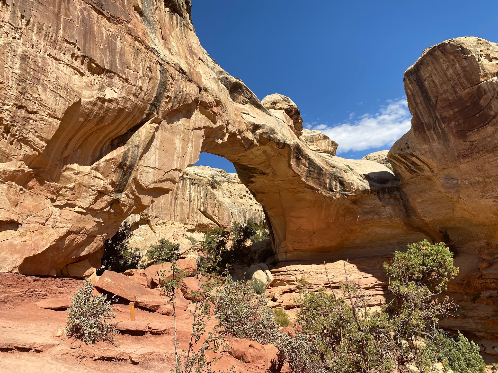
5 June 2021 Hickman and Sulfur
We were up early again this morning. We were headed for Hickman Natural Bridge trail (2.6 Miles, 584 feet of elevation gain, 1721 calories burned) just off Utah 24. This is a very popular trail that we had noticed the parking lot was always overflowing when we drove past before, so we figured we needed to be there early to get a parking spot. We arrived at the parking lot about 8:30 and it was already full, but fortunately there were open spots along Utah 24 big enough for the Behemoth. The first part of the trail is a steep climb over a ridge then down into a dry wash. You hike along the dry wash for half a mile. In the dry wash we found the Nels Johnson Natural Bridges. Two little short bridges with a gap in between with a pour off at the back end. They were cute. But more importantly there was shade. Although the temperature was in the low 70s when we started, they were climbing very quickly and there was very little shade up to this spot. After cooling off we continued up the wash to the final steep climb up to the base of the Hickman Natural Bridge. Impressive in its size (third largest in the US), the bridge sits over a still eroding wash of soft stone. We found a nice seat in the shade of the bridge and drank lots of water. We watched two families that were down below the bridge taking a break. Their young son began climbing up the steep, slippery walls until he was at a ledge 70-80 feet up. The parents were not paying any attention and even when he called to them, they ignored him. He wandered along that slim ledge until he was under the foot of the bridge and squirmed his way around the steep slippery base. One misstep and he would have landed 80 feet down on hard rock. Parents did not seem to care! In fact they let the other kids with them climb up to the same ledge! We ended up running into this group a couple times the rest of the day and talking with them. Good thing I was never a parent!
The hike out was very hot. The temperature had climbed into the mid 90s in just a couple of hours. We arrived at the Behemoth grateful for the air-conditioner! Leslie had read about another trail nearby that you walk up through the creek bed in the water to a series of waterfalls. The trail, Sulfur Creek (2.1 miles, 197 feet of elevation gain, 1089 calories burned), starts out behind the visitor center. After finding a parking space across the road from the visitor center, we changed into our water shoes and headed up the streambed. The water felt cool on our feet, which made the hike up the stream pleasant. At the first waterfall, there was a large, deep in spots, pool of water with a nice natural water slide at the far end. The place was pack with young kids sliding down the waterfall or climbing the cliffs to jump in. We could see a few people climbing up the slippery walls to a narrow ledge to work their way around the fall to continue up the creek, but we decided we would turn around at this point. After soaking our feet in the cool water and watching the antics of the kids for a while, we headed back to the Behemoth, content for the day. |
| Nels Johnson Natural Bridges |
 |
| Looking up between the two Nels Johnson Bridges |
 |
| Hickman Natural Bridge |
 |
| Looking up at Hickman Bridge |
 |
| US standing in front of Capitol Reef Valley |
 |
| First Waterfall of Sulfur Creek |
 |
| Sulfer Creek |
 |
| David Taking a break |
Friday, June 4, 2021
4 June 2021 Grand Wash
We were up early and headed to Capitol Reef NP before 7:30 for two reasons, one to start our hikes in the cool of the morning and to get to Gifford House to buy some pies before they ran out. A ranger had advised us that we should be at the Gifford House before 8 am to get in line if we wanted a good selection. We arrived in the parking lot just before 8am and there was a line waiting for the store to open. The Gifford House is an old ranch house that they have made into a bakery and museum. They are famous for their freshly made personal sized pies. But they normally run out in just a couple of hours. The fruit for the pies is grown in the historic area for Fruita in the park. There were maybe 20 people ahead of us. But there were plenty of pies when we got up to the counter. We got an incredible looking cinnamon bun, one rhubarb/strawberry pie, one cherry pie, two peach pies and one apple pies. Enough to feed us breakfast for several mornings. We then drove to the trailhead for Grand Wash trail at the end of a dirt road. We arrived about 08:30 and got the last spot in the lot. Having secured our parking, we broke open one of the peach pies and shared it between us. It was DELICIOUS!! Now, fully charged up with sugar, we grabbed our hiking gear and headed out on the Grand Wash trail. Its an easy hike, even though you gain/lose 500 feet in elevation. The trail follows the dry wash through the canyon. We got to where the trail breaks off the Cassidy Arch. We briefly considered taking trail, but it zigzags steeply up the side of the canyon wall to the top of the mesa. There did not look to be any shade (later confirmed when talking to other hikers), and the temperatures were supposed to climb into the mid 90s. So we decided to continue down the Grand Wash to the far end of the Narrows and then back to the Behemoth. The canyon was pretty but it never got narrower than 30 feet, so not a real slot canyon. On the way back, we were going up hill. The sun was higher in the sky so there was very little shade.
Back at the Behemoth we could see cars parked haphazardly along the road. So it was clear that parking was a premium. We had considered hiking Capitol Gorge trail, but that parking lot was even smaller than Grand Wash. So we decided to go down to the petroglyphs along Utah 24. On the way out from the trailhead we stopped at an exhibit for a couple of Uranium Mine shafts. In the 1950s, the Atomic Energy Commission was offering large bonuses for Uranium and the federal government opened all public lands, including National Park lands for Uranium exploration and mining. We walked up to the mine shafts and peered in between the bars blocking entry. There was a sign warning of radiation hazard and just below it was a sign saying it was protected bat habitat.
They have a boardwalk to view the petroglyphs from but between the distance and the weathering, they are hard to view well. They believe the petroglyphs are from 400 to 1300AD. After the petrogylphs, we continued east on 24 until we found a waterfall on the Fremont River that Leslie had noticed. But there was a sign declaring the area was closed due to safety concerns. But we were able to walk along the road until we could get pictures of the falls. After the falls, we drove to the Goosenecks Trailhead. It’s a short trail that takes you to an overlook for the canyon carved by Sulphur Creek. The storm clouds were building with some rolling thunder in the distance, so we decided to head back to the Wanderer for lunch, but stopped at a small Mexican Restaurant in Torrey before getting back to the Wanderer for a leisurely afternoon.
 |
| Peering through a rock window at Grand Wash |
 |
| David along a weathered warn rock |
 |
| View from Gooseneck Point |
 |
| Fremont River Fall along 24 |
 |
| Petroglyphs along 24 |

 |
| The Narrows in Grand Wash |
 |
| Standing in line at Gifford House for pies |
31 May 2021 Hanksville to Torrey Utah
We left Hanksville behind and headed for Torrey (Only 1.5 hour drive), just outside Capitol Reef NP. We had to drive through a portion of the park along the Fremont River on the way. We are staying at Thousand Lakes RV Park ($40.40 per night, no discount) on the west side of Torrey. The road through the park was pretty bumpy and felt very narrow. But the view was wonderful with towering cliffs on both sides of the road. After getting set up, we drove back to the park and stopped at Panorama Point before going to the visitor center. As with many other parks, the exhibits and movie were still closed due to Covid, but the bookstore was open. So we stopped in to get some post cards and David’s park hat. We stopped to speak with the ranger to get some hiking information but she was not very helpful. But we got the scoop on getting Gifford House Pies from another ranger. We then drove the scenic drive into the park. The cliff faces were very imposing, towering and had so many colors in them. We took the road until the pavement ended and we continued on the dirt road into Capitol Gorge. The cliffs hung over us as we negotiated the narrow gorge to the end of the road before turning around and heading back. 
View from our campsite in Torrey 
Driving through Capitol Gorge 
Entering Capitol Gorge 
The Capitol Reef 
More Capitol Reef 
And even more Capitol Reef 
Entrance sign