Sunday, July 29, 2018

29 July 2018 Pipestone National Monument

We drove (1 hour) up to Pipestone NM in southwestern Minnesota. The NM is only 300 acres in size and encompasses multiple quarries where Native American Indian Tribes mined catlinite, a soft stone formed from ancient clay, which was carved into pipe bowls. The catlinite is under multiple layers of Quartzite, which have to be removed by hand. There are piles of quartzite from hundreds of years of mining. The tribes still mine on the site today. The stone is cut and carved using tools similar to basic wood working tools. It is only slightly harder than a fingernail. There were a couple native artists in the visitor center that we watched mold the stone into pipe bowls. They would smoke leaves from wild tobacco plants and Sumac. We hiked the ¾ mile Circle Trail, which takes you past the Sioux Cliffs, numerous quarries, and Winnewissa Falls. 
One of the Quarry Sites. You can see a hand shovel under the water on the left

Winnewissa Falls

Leslie and David in front of Winnewissa Falls

In the distance we could hear the ceremonial drums and chats of an Indian tribe holding a Sun Dance, where the Indians dance and pray for their people, their families, and the health and happiness of all living things.   It’s a Native American ceremony that requires fasting (no food or water) and dancing for four days, inviting one’s soul close to death in order to speak with the spirits.   The Ranger at the Visitors Center mentioned several protocols to follow if we wanted to go and watch.    The women required long skirts or dresses and a shawl.  Without those, stop by the kitchen and ask for help.  No jewelry is allowed and neither are eyeglasses of any kind.  No recording or photography equipment is allowed.  It is suggested that while at the Sundance or sweatlodge ceremonies, it is easy to let your emotions and feelings wander.  They ask that you please keep all negative feelings in control and refrain from arguments and gossip.  If we could practice such control today…who knows.    It’s a surprising little NM in the middle of prairie and unique in that it is a living monument which continues age old traditions today.  

28 July 2018 Sioux Falls SD

We drove into town and tried the local Mexican food (Aztec) and were very disappointed. Everything was fresh but there was no spice. Then we went down to Falls Park. As the name suggests, the park wraps around the Sioux River and the tall water falls. Over time, various people have tried to harness the power of the water. The remains of a gristmill and electric plant litter the banks of the river. Portions of the falls were quarried to help with the water flow for the electric plant. The falls are impressive and the park around them is well maintained and pretty. From the falls we went down to Phillips Street in the downtown quarter. It was similar to Main Street in Sundance Square. The buildings are 100 years old and well maintained. Shops are interspersed with restaurants and pubs with street side seating. There are sculptures sprinkled along the walkways and hysterical markers. The weather was beautiful and begged us to sit in a street side patio for a local brew. 
Sioux Falls

Sioux Falls


27 July 2018 Custer SD to Sioux Falls SD

We left Custer and drove down to Rapid City where we picked up I-90 East to Sioux Falls.  There is NOTHING between Sioux Falls and Rapid City. The land is flat with miles and miles of either prairie grass or massive fields of corn. We stayed in Sioux Falls at the KOA ($64 a night). The KOA has gravel roads and gravel sites which were not very level. But water pressure is good, WiFi was great, no cable, but our pull through had a lot of room for our fiver. They had a nice dog run, putt putt course and a small pool. The weather for the drive was cool and windy (we averaged 8.4 MPH). 

Thursday, July 26, 2018

25 July 2018 Hot Springs South Dakota

This morning we drove down to the small town of Hot Springs (about an hour south of Custer). There we had a not so quick unremarkable lunch at the Vault Bar and Grill. It was the only non-fast food restaurant in town open on a Wednesday afternoon. When we walked in, we were warned it would take our food 45 minutes to come out. Not being in a hurry, we sat down and ordered anyway. It only took 35 minutes and our appetizer came out after our meals. The town is actually pretty interesting. Main street runs along side a small river and there is a spring fed water fall across from the bakery. Many of the buildings are made out of local sand stone and are quite ornate. 


After lunch we went to the Mammoth Site ($12 per person) and took the tour of an archeological dig of what had once been an Artesian Watering hole during the last ice age (11,000 to 12,000 years ago). The site was discovered in 1974 by a construction crew. It is theorized that this mound had once been a watering hole that was caused when limestone under the site was dissolved by acidic water and the upper layers collapsed causing a deep watering hole. The water table filled the slump with 98F water, which allowed grasses to grow around the edge of the slump. This attracted the Mammoths (Colonial and Wooly) and other animals. When the Mammoths climbed down to get the grasses and water, they would slide in because the sides were very slippery. Once in, they could not get out and would die and sink to the bottom where they would be covered by clay mud and preserved. They have identified at least 66 sets of Mammoth bones in addition to flat faced bear, ancient Lammas, camels, wolves, prairie dogs, fish, and other various rodents. It is estimated it will take another 120 years to complete the excavation.


We then went to the Prairie Museum ($5 per person) up on top the hill overlooking the town. It was formally the schoolhouse and was used from 1896 until 1964. It too is made out of local quarried sandstone. The rooms were filled with antiques that had been donated by locals and had that old musty smell. These are always fun to walk through because you will see things that make you go “What was that used for?” and others that remind you of things you saw in your grandparent and great grandparents homes. The old wooden floors and stairs creaked and were uneven from the wear and tear of tens of thousands of kids over the decades.

On the drive back, Leslie noticed a small shack at the side of the road with a sign advertising it as a B&B. We had to turn around and get a picture, which she has since shared with her former boss and her friend and former assistant manger Mona. Anyone looking for a fixer upper B&B?

Monday, July 23, 2018

22 July 2018 Wind Cave National Park

Following our first visit to Wind Cave National Park, we decided we wanted to come back and do a hike. Today the weather forecast was sunny and in the low 80s. A good day for a hike. Once again we had heavy rains last night so decided we would check in at the ranger station for any trail closure information and David needed to pick up a Wind Cave NP ball cap to add to his new collection. The Rangers had no information for the trail we planned to hike but warned us the streams would be full from the recent rains. Seems this part of South Dakota is having a wetter year than normal in that they have already exceeded the average yearly rainfall. We decided to hike the Lookout Point trail that when combined with parts of the Highland Creek and Centennial trail forms a 4.5 mile loop. The Look Out Point trail meanders through highland prairie grass. We choose to wear shorts for this hike since the temperatures were expected to be in the low 80s. We quickly realized this was not the best plan as our bare legs were getting brushed by all the prairie grasses and weeds. But even worse, less than a quarter of a mile from the trailhead we came across our first batch of poison ivy. A noxious three leaf plant (beware thee of leaves of three) whose sap can cause blistering and rashes to exposed skin. Little did we realize we would have to work through more poison ivy than either of us had seen in our lives times a million!! Anywhere there was a shady area there was poison ivy we had to gingerly walk through or around. At times it was only on one side of the trail, which was easy to avoid. Other times it was on both sides and we had to pick our way down the trail twisting and turning to avoid having it touch our bare legs. At one point we had to wade across a stream because the poison ivy was too thick on the trail to get to the bridge. If we had any clue about how much of it we would run into, we would have turned around at the first patch. But, somehow we managed to avoid getting any rashes or blisters. The first two miles of the Lookout Point trail is through tall prairie grass with lots of prairie dog towns with plenty of signs of buffalo. 


At first, the warning chirps of the prairie dogs was cute and they were fun to watch. But after a couple of miles of it, those chirps just got to be annoying. There were thousands of those little rodents! We started to hear thunder overhead and the clouds began to thicken. At the two mile mark, Lookout Point trail intersects the Highland Creek trail and the two join up. At this point we started to enter some forested areas and the ever present poison ivy. It also began to drizzle. Between the rain and our sweat, we were soaked. 

We came into a large field and found there was a large buffalo bull lounging in the grass and occasionally rolling on its back to wiggle in the dirt. Seeing a massive, 1000lb+ animal, wiggling upside down like a little puppy was a sight to behold. As we walked along the trail, he got up on his feet and stared at us. Being out in the open with this massive beast poised to run you into the ground definitely heightens one’s senses. There was no place to run and hide if he decided he did not like us. Fortunately he just stood there and stared as we worked our way down the trail. 

Movie please run.


A half-mile after the Lookout Point trail and Highland Creek come together, the Highland Creek trail splits off and we are hiking on the southernmost portion of the South Dakota Centennial trail. The 110 mile Centennial Trail starts at where we parked and works its way north through the Black Hills to the town of Lead. On this portion of the loop, the poison ivy was thickest. We were only 2 miles from the truck but it seemed like a lot further. The area the trail followed was along side a little creek that we had to cross over multiple times. Beautiful cliffs popped up on either side with forests of Ponderosa Pines and at points the creek ran along the bottom of the cliffs. The water was flowing high and fast due to last nights rain and was surprising cold! If it had not been for the damn poison ivy, it would have been a beautiful portion of the trail. Soon we were back at the truck. We drove the scenic route up through the National park and into Custer State Park before reaching the Wanderer. 


Saturday, July 21, 2018

21 July 2018 Golden Discovery Days

Custer was hosting the Golden Discovery Days festival this weekend. We slept in to recover from our long day yesterday. We then went into town and toured the festival vendors and activities. The venders were all-local to South Dakota and had some interesting wares. We had lunch on the rooftop at Bugling Bull and once again were disappointed with the quality of the food. 

From David: David worked on projects on the Wanderer. He caulked the seam around the skylight with silicone. It rained hard later in the day and his handiwork seemed to have worked. We also came up with a better way to secure the refrigerator doors. David opened the garage and we were happy to see things had not shifted too much. David decided to better secure the ladder as well as the kayaks.

From Leslie: Please refer to the book “Dear Bob and Sue” by Matt and Karen Smith.  A fun, laugh out loud summer or anytime read about a couple which retired and determined to visit all 59 National Parks.  There is a chapter for each park.  Enjoy!  We resemble some of those chapters.  However, instead of a pelt collection, David is starting a baseball cap collection (better than trying to preserve pelts!).

20 July 2018 Minuteman National Historic Site and Badlands National Monument

We drove from Custer to exit 131 on I-90, a two-hour drive from Custer. The visitor Center for the Minuteman National Historic Site is located just off this exit. The visitor center has a film of the Minuteman’s role in the US Defenses in the Cold War and exhibits of the equipment in the launch control centers (LCC) and missile tubes. They offer a guided tour of a LCC that was saved from destruction following the signing of the START II treaty when all the rest of the Minuteman LCC and missile tubes in South Dakota were destroyed. We had Etta with us since it was going to be a long day and that prevented us from taking any tours or doing any hikes. So we took turns going into the visitor center while one stayed in the truck with Etta. We collected our stamp (#10) and took turns seeing the film and exhibits.

From the national monument, Badlands National Park is a ten-minute drive south. Words and photos can’t begin to describe the impact and expanse of the Badlands. One wonders what the pioneers felt when they came across this land. Awe, dread, fear? It stretches as far as you can see, and out here you can see a long way. We drove the Badlands Loop Road, which runs along the north side of the “cliff wall” where the land is eroding into the valleys in the Badlands. There are lots of overlooks to stop at with short trails. We would take turns doing the trails to get photos and staying with Etta or taking her for walks. We stopped at the Ben Reifel Visitor Center to collect our stamp (#11) and talk with the Rangers about options. We drove the loop road of the park and took the gravel Sage Creek Rim Road along the North West side of the park and then down until it intersected route 44. Along it we saw Buffalo, Big Horn Sheep and Prong Horns. We then went into the small town of Scenic before going into the Pine Ridge Indian Reservation on route 27. This took us into the South Western portion of the park where we took another gravel road up to Sheep Mountain Table. Coming off of Sheep Mountain we continued on to the White River Visitor Center but got there just after in closed. So we continued west along Reservation Route 2. The prairie rolled out for miles and miles with occasional rock formations. The road was so straight that we could have tied the steering wheel and taken a nap! It just went on and on. Eventually we ran into reservation route 41 (South Dakota route 40) and followed that North to Hermosa. From there we made our way back to Custer through Custer State Park. We had to keep a close eye out for Deer, and we saw several along the road side. Eleven hours after we left, we finally pulled up to the Wanderer. We dropped Etta off and fed her dinner. We then went out to Captains Table for dinner. When we walked in we felt we had been transported back to the 1950s. We ordered the 20Oz Prime Rib and split it. The beef was advertised as grass fed locally sourced beef. It was fairly dry and not very favorable for a Prime Rib. We would not recommend this restaurant if you ever come here. 


Tuesday, July 17, 2018

16 July 2018 Devils Tower National Monument

It rained again last night but was clearing to the west, so we droves out to Devils Tower National Monument in Wyoming. It was a two-hour drive over some very pretty country. As we pulled into the NM, the tower loomed over us. It is an incredible sight. The tower is over 60million years old. It is formed from igneous rock (magma) that was pushed up and cooled. There are different theories of how it was formed with no firm consensus. We arrived in time for the 10am ranger led tour around the base of the formation. This tour was not as Jr. Ranger oriented and the Ranger did a nice job of keeping everyone moving. The trail was paved all the way but was fairly steep in places. There were numerous climbers on the tower either working their way up or having already made it to the top, were roping down. Devils Tower was the first National Monument designated by President Roosevelt 1in 1906 following passage of the Antiquities Act.  The visitor center was small and did not have much in the way of exhibits. The parking was limited also, but we arrived early enough to get a spot in the overflow parking. Just outside the gate to the NM there is a KOA camp ground with RV spots. Something to keep in mind if we come back. It would have been nice to be able to stay until sunset to see the colors on the tower. Unfortunately we could not stay longer since we needed to get back to the Wanderer so we could let Etta out. 


15 July 2018 Jewel Cave National Monument

Last night and this morning it rained hard. Just up the hill from us on the other side of the gravel road, they are doing construction to add additional RV sites. The rain washed a lot of dirt out of the construction site and across the gravel road. Lucky for us there is a little hump directly behind our Wanderer so the mud filled water was diverted into the two sites next to us (not so lucky for them). With more rain forecasted for the afternoon, we decided to stay closer to “home” (Home is where we park the Wanderer these days) and went to Jewel Cave National Monument. Jewel cave was discovered by Frank and Albert Michaud who were riding their horses and heard a whistling noise. When they investigated, they found a small hole in the ground with cool air forcing its way out. The hole was too small for them to crawl through, so they went into Rapid City and bought mining tools and dynamite and blasted a larger opening into the cave. Seeing the Calcite crystals on the wall, they figured they had hit the jackpot and rode back to Rapid City to file a mining claim for the Jewel Tunnel Load. They never did find any jewels and eventually turned to trying to make money giving tours like they were doing at Wind Cave. But Jewel Cave was too remote and they never made much off the mine. In 1908, the cave was made a National Monument by President Roosevelt. The reason this cave is a National Monument verses a National Park (like Wind Cave) is because of the signing of the Antiquities Act of 1906. The Antiquities Act gave the president the ability to set aside government owned lands for the preservation of resources and place of historical or geological importance. A National Park designation takes an act of congress. So Wind Cave was made a National Park before the Antiquities Act and Jewel Cave was made a National Monument because of the Antiquities Act.

We arrived at Jewel cave about 9:20 to find all the Ranger Led tours before 12:40 had already been sold out. So we grabbed two tickets ($12 each) for the 12:40 Scenic Tour. There was a ranger led tour at 10am that walked the Roof Trail. So we got our stamp (#8), explored the exhibits in the visitor center until 10am and caught the Ranger led tour. Our first hint of what was to come should have been the number of kids with Jr. Ranger Badges and books that were in the tour. Alas, the tour was orient more towards the kids with little tid bits for us adults. We learned that the Joshua fire in 2000 burned a large segment of the Monument due to the amount of brush that had built up over the years of immediately stopping forest fires instead of recognizing they were a important part of the ecosystem. The Joshua fire, which was caused by arson, burned particularly hot and not only burned up the Ponderosa Pines but also the roots of the prairie grasses and the pinecones. So recovery was going very slow. But from what we could see, it was a sea of green grasses and burned tree stumps. The Young Man leading the tour was a college student working for the summer at the monument through the Student Conservation Association (SCA). His major was in Climate Engineering. Don’t ask me what that means, but it sounds suspiciously like something to do with Global Warming. With two hours left to kill, we drove back to the Wanderer for a quick lunch before going back for our Cave tour. 

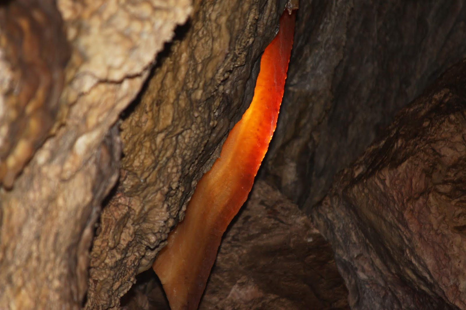
Our guide for the tour was Ranger Cave Guide. It seems the US mail had lost her ranger badge with her name on it, Jennifer, so her name badge was Cave Guide. Before going down the elevators, we learned that Jewel cave was the third largest cave in the world with over 195 miles to date. They believe they have only mapped 5% of the cave so far. The day we were there, a team of cave explorers was headed in for four days of mapping new parts of the cave.  The walls of this cave were covered with Nailhead Spar calcite formations several inches thick. This cave stayed wetter, longer than Wind Cave resulting in the formation of the Nailhead Spar. The colors changed in different parts of the cave due to the different minerals present in different parts of the cave. One of the people on the tour was carrying a 9 month old baby in a chest harness. Now why a mother would take a young baby into a slippery, wet, and cold cave is beyond me. Although the baby never cried loudly, it blubbered, wailed, and made loud baby noises for the whole tour. In the cave, it was loud enough that he would drown out the Ranger if you were close. So we spent part of our time trying to make sure we did not get stuck close to the cute blubbering babe after each stop. The entrance we went through was installed in the 1960s. The historic entrance, that the Michoud brothers blasted out, only allowed access to a small portion of the cave. A portion of the cave was wet so there was beautiful flow formations, Cave Bacon, tubes, and stalagmites and stalactites. The temperature was colder than Wind Cave (49F) and damper (98% humidity). David had to keep ducking due to the low ceilings and we had to watch our footing due to the dampness. But it was an enjoyable tour and Ranger Jennifer made the tour interesting (when we could hear her over blubbering baby).
Flow Formation

Cave Bacon Formation


When we exited the cave, we had hoped to go hiking, but the rain clouds were threatening so we headed back. Maybe we will come back later in the week to hike.  

Saturday, July 14, 2018

13 July 2018 Wind Cave National Park

We woke early today to make it to the park in time for the early morning cave tours, before the crowds closed in. We took the Natural Entrance tour ($12), which started 10 minutes after we arrived. The “Natural Cave” entrance is not really an entrance as it is more of a small hole that only a small child could squeeze through. 
Natural Entrance to Wind Cave
When the cave was first opened up in early 1889 for tours by the McDonald family, they excavated an entrance into the cave that started from their log cabin. The young son, Alvin, was the first true explorer of the cave, which is now ranked as the third largest in the world (Mammoth Cave is number 1 and Jewel Cave is number 2). 148 miles of passages have been mapped so far. They estimate only 10% of the cave has been mapped so far. Young Alvin McDonald explored the first 8-10 miles of the cave and led tours into the cave by candle light until he passed away at age 19 in 1891. They still find remnants of the twine he used to find his way back out. In 1901, the US Government took over the land and the cave. In 1903 it was made a National Park.  Much of the work to make the cave more accessible was accomplished by the CCC in the 1930s. The cave contains 95% of the Box Lattice formations in the world. The formations were caused by limestone cracking under great pressure, and Calcite formed in the cracks over time. Then slightly acidic water melted away the surrounding limestone over millions of years leaving the calcite box formations and the cave found today.  After the tour we collected passport stamp #7 and toured the exhibits in the visitor center. 
Box Lattice Formation
Following the exhibits we hiked the Wind Cave Canyon Trail (approximately 4 miles) to stretch our legs. The terrain varied between prairie and pine forest. We did not see any wild life. We plan to come back and hike some of the other trails. 

Thursday, July 12, 2018

11 July 2018 Custer State Park, Mount Rushmore National Memorial and Crazy Horse Memorial

Today we started our tour of the local National Park Units. We started with a picturesque drive through Custer State Park. We stopped and petted the “wild” burros along the side of the road. They are descendants of Burros that were used to haul tourists up and down Black Elk Peak that were released into the park when they stopped those tours. We also got to see a portion for the South Dakota Buffalo Herd that resides in the state park when they blocked the road for an hour. The herd numbers around 1300-1400 head in the park. Their numbers are managed to the amount of range available in the park.
Leslie petting one of the "Wild" Burros

Part of the South Dakota State Buffalo Herd

We then went on to Mount Rushmore. The drive was twisty and windy, going through three narrow one-car tunnels, and in multiple places doubled back on themselves. Leslie was challenged by the roads but did great! Mount Rushmore National Memorial is incredible. The pictures do not do it justice. We collect passport stamp #6 before watching the history film on the memorial, visiting the Museum and Presidential Trail (at least the portion that was open). Parts of the park were closed (the sculptors studio, Borglum Terrace and that portion of the Presidential trail). The work that was done, with about 400 laborers, to create these four sculptures in only 14 years (1927-1941) is incredible. The cost for the original monument was less than 1 million dollars. Of which 85% was federal funding. The Sculptor Gutzon Borglum, died just month before it was finished.  
Mount Rushmore (Presidents Washington, Jefferson, Roosevelt and Lincoln)
  

After a quick stop at the Wanderer to let Etta out for a walk, we drove to Crazy Horse Memorial. Crazy Horse Memorial was started in 1947. It’s completely private financing from donations and admission charges ($12 per person). The face was completed in 1987. Work is still ongoing on the outstretched arm and horse head. In scale, Crazy Horse is roughly 10 times the size of any of the Sculptures in Mount Rushmore. The Sculptor, Korczack Ziolkowski, originally worked on Mount Rushmore under, Gutzon Borglum.  Ziolkowski was requested 1939 to do the Indian memorial by Chief Standing Bear. The tribes decided that Chief Crazy Horse would be the Chief immortalized in the mountain, partially due to his victory at Little Big Horn over General Custer. Ziolkowski passed away in the 1990’s. His wife and some of their 10 children are continuing the work. There is no set date for completion of the memorial. The Memorial also acts as a repository of Indian cultural artifacts and the Indian University of North America. 
Chief Crazy Horse Memorial


After Crazy Horse, we went back to Custer because David has been dying to try the Purple Pie Place. We decided we would have desert before dinner tonight. But once we entered the shop, we saw they also had delicious looking Chicken Pot pies, so we got dinner also. David got the strawberry-Rhubarb pie alamode and Leslie got the Raspberry-Rhubarb-Jalapeno pie. Both the desert pies and the Chicken Pot pies were fantastic. If you are ever in Custer, we strongly recommend you visit the Purple Pie Place.

The Purple Pie Place was of course painted purple.  It looked like the kind of place parents might book a child’s birthday party.  There was lots of pie and ice cream.  Leslie truly thought David may have been out in the sun too long, but She gave him credit as he hit a home run with this one!  It was a great way to top off a great day.

10 July 2018 Rapid City

Today was a catch up day. We did laundry, cleaning and general getting caught up with ourselves. We filled out our Volunteer In The Park (VIP) applications for Big Bend National Park and got them in the mail. We drove down to Rapid City to pick up a prescription and do a little grocery shopping. Its roughly an hour drive each way. The roads are not very windy or difficult. Getting prescriptions on the road is going to be interesting since we have to transfer each prescription from the previous pharmacy to the new pharmacy. It all takes time, even within the same pharmacy chain. On the way back we stopped off in Hill at the Prairie Berry Winery and Miner Brew House to try the local wines and brews. Surprising they were actually pretty good and we walked out with half a case of wine. 

Tuesday, July 10, 2018

9 July 2018 Gerling SE to Custer SD

We drove From Gerling NE to Custer SD taking US 26 West into Wyoming (5thstate), US85 North and then US16 east into the Black hills. It only took us about 4 hours. US85 North was pretty bumpy with frost heaves at the road joints. So things got jostled around pretty good. The truck ran a bit hot like the previous few days of towing, but towed the Wanderer up the mountains just fine. We even passed a semi on one of the climbs. I was impressed but how much power this truck has. The down hill assist was a help as well. We are staying at the Buffalo Ridge Camp Resort ($49 per night) just outside Custer.  The sites are pretty close together, gravel roads and sites, and sloping. The back of the Wanderer is only a few inches above the ground by the time we got it level. Getting out of here is going to be interesting. Water pressure is good and the Wi-Fi is strong. We probably would not choose to stay here again but it will be fine for the next couple of weeks. David forgot to strap the refrigerator closed so we opened the door to find beer sloshing around on the floor from a bottle the found its way out. So we spent part of the afternoon cleaning it up. Vowing to always use the departure checklist from this point on! We went into Custer for dinner. A quaint little town that we will explore more in the future. We ate at the Bugling Bull. David had the Walleye and Leslie the Buffalo Short Ribs. Both were really good!! Tomorrow we are taking as a down day to catch up on laundry and David needs to do some work.

Sunday, July 8, 2018

8 July 2018 Agate Fossil Beds NM

We drove an hour north of Scotts Bluff to the Agate Fossil beds National Monument. At the entrance to the park there is a hiking trail, Daemonelix Trail, out to some stone outcroppings which contained fossilized rodent dens that spiral down from what was then (21 Million Years ago) surface level upwards of 10 feet to a den. These are called devils corkscrews. We then went to the visitor center, collected our passport stamp (#5) and decided to do the other trail in the park, Fossil Hills Trail, before it got really hot. We hiked up to University Hill and Carnegie Hill where the major fossil beds were excavated between 1892 and 1928. The excavations at these sites were water holes that slowly dried up and thousands of animals died on the shores, which produced the fossil beds. The last major excavation in the park was in 1986. We could not see any fossils or any real indication of the previous excavations. It was a rather disappointing hike. Back at the visitor center I talked with the park ranger and she said that they have a paleontologist that comes out once or twice a year to check if erosion has uncovered any fossils. If there are, the evaluate them to see if they are something new or not. If not, they put a preservative on them and rebury them. Apparently there has not been anything new since 1986. We went through the museum in the visitor center before heading back to Gerling. Leslie has decided that driving in Nebraska is boring, it has eight legged biting flies, and a lot of ants. Tomorrow we drive to Custer South Dakota.

Fossilized Rodent Burrow

Fossils on exhibit in the visitor center

7 July 2018 Scotts Bluff NM

We drove along the Lincoln Highway, US30, out of North Platte. This is the same US30 that runs past Canton, Ohio. We had to detour on to I-80 due to construction on US30 and got off at Ogallala to pick up US26. Interestingly, Ogallala claims to be the Cowboy Capitol and also had a Boot Hill the same as Dodge City. How many Cowboy Capitols and Boot Hills can there be? On the way up US26, we came across Chimney Rock National Historic Park (Stamp #3) and pulled in. Chimney Rock was a major landmark to the settler crossing the plains indicating the end of the prairie/plains and the start of the mountains. It was also a navigation landmark for the plains Indians. We proceeding up US26 to Gerling, where we pulled into the Robidoux RV Park ($27 per nigh with Good Sam discount). The roads are paved but very narrow as in our site. The water pressure is very good as is the Wi-Fi. There is lots of green space to walk Etta. We would stay here again.


We could see Scotts Bluff from our RV spot. After we set up and got the Wanderer cooled off enough for Etta, we drove up to Scotts Bluff National Monument. At this point along the North Platte River, the three major 1850s settler trails to the west come together. The Oregon and California trails follow the south shore of the North Platte River and the Mormon Trail followed the north shore of the North Platte. At Scotts Bluffs, the settlers had to detour south to Robidoux pass to get around the Bluffs until the army pushed through a trail through Mitchells Pass between the two bluffs of Scotts Bluff NM. This shaved 8 miles off the settlers trek. From here the trails continue west into Wyoming and to the South Pass of the Rock Mountains before the split to go to their various west coast destinations. Over 350,000 settlers passed this point between 1841 and 1869. At times there were traffic jams getting through the pass. The wagon trains strived to be at Scotts Bluff (also called the Nebraska Gibraltar) by early June to be able to make it through the Rocky Mountains and the costal mountains before winter. Scotts Bluff marked the roughly 1/3 poin in their journey west.

After touring the Visitor Center and collecting our passport stamp (#4), we drove to the top of the Bluff for magnificent views of the western plains. After we came back down, we drove through Mitchells Pass and turned off on a side road where the truck navigation system indicated we could see the Oregon Trail ruts. The “road” wound past a private home and turned into two dirt ruts. There were no signs telling us where to go. We drove a short distance in these ruts before we suddenly thought that we might actually be driving in the ruts of the Oregon Trail! We quickly turned around and drove back to the highway!

6 July 2018 Dodge City KS to North Platte NE

Today we drove from Dodge City to North Platte. It was another hot day and again the cooling system and transmission were running a bit hotter than normal but nowhere near overheating. We stayed at the Holiday RV Park ($42 a night with Good Sam discount). The roads are all gravel but the sites were level, shady and easy to pull into with our big rig. Water pressure was good and Wi-Fi fast. We would stay here again.

Last night, David notice that our route from North Platte to Custer was going to take us within 100 miles of two National Monuments in the western most part of Nebraska. So we looked over our options, rearrange our reservations and cut our stay in North Platte to one night. 

Thursday, July 5, 2018

4 July 2018 Dodge City KS

Today we explored Dodge City, famous as the backdrop for the TV show Gunsmoke. The town has seen it fair share of ups and downs. We took the tour trolly to get the lay of the town and then walked the historic downtown before going to the Boot Hill museum. The town was founded in 1872, just before the AT&SF railroad reached town. It was a hub for buffalo hunting and cattle drives from Texas from 1872-1885. Fort Dodge was establish in 1868 to protect the wagons on the Santa Fe trail from the Comanche Indians. The Santa Fe trail ran along the river through town. The US Calvary soon figured out they could not beat the Comanche with regular tactics and authorized private hunter to kill the tens of millions of buffalo that ran on the plains and were the primary food source for the Comanche’s. The Buffalo hides were needed out east (the center of the hide, along the back bone, was roughly and inch thick which made ideal belts for the steam powered machinery of the start of the industrial age). Within 3 years over 5 million buffalo had been slaughtered. In 1971, the need for beef in the east caused herders to begin to drive massive herds of wild Texas longhorn to the rail hubs in Kansas. In 1885, the Kansas legislature passed a ban on Texas Longhorns entering the state due to a tick bourn disease that infected the Kansas beef herds. This followed by a bad winter in 1885-86, which decimated the local beef herds. In addition, most of the buildings along the towns North and South (split by the railroad track) Front Street burned to the ground. Boot hill was so named because of the gunslingers and cowboys that were buried on the hill just to the north of the rail road. The unofficial cemetery only held and estimated 30-60 bodies before the town opened an official cemetery further outside town. 32 remains, many remarkably well preserved by the clay soil were moved from Boot Hill in 1879. In 1872 alone, 15 gun fight victims were buried on Boot Hill. Only one woman was buried on Boot Hill. But the town became famous for Boot Hill in the 1870s. Now the town is primarily a beef town with massive feedlots and three meat packing plants.
Leslie playing cards with Doc Holiday

Boot Hill Museum reproduction of the Dodge City Front Street of 1885
We got most of this history from Special Sheriff Charlie Meade who met us on the sidewalk on Front street and gave us the history of the town. Charlie was a former deputy Marshall in Dodge for over 30 years. He is a very interesting guy to talk too.

In the evening, we climbed the hill next to the RV park and could see fire work shows for miles in almost every direction. We could see fire works shows from town over 30 miles away. Many private ranches were shooting off fireworks as well. It was a great way to spend the day. Just before we went to bed, David noticed the water pressure was low, so he went outside to see if he could see what was wrong. Sure enough, our fresh water hose that connects the wanderer to city water had sprung a leak. He shut the water off and we ran the night off the fresh water tank. We’ll get a new hose in the morning. Tomorrow we are catching up with chores.

Tuesday, July 3, 2018

3 July 2018 Amarillo TX to Dodge City KS

Today we traveled from Amarillo to Dodge City. We had a strong south wind starting about the time we turned north so we got 9 miles to the gallon! This was mostly prairie landscape, so we could see forever, but there was nothing to see except grass. We are staying at the Gunsmoke RV Park (Good Sam) outside Dodge City, site 60, $39 a night. We ran into Gary Metcalf (his wife Jan) who own the other New Horizon that was in the Oasis RV Park. Gary and Jan were at the New Horizons factory at the same time we were picking up our rig in August 2017. So we compared notes on New Horizons and our experiences so far with our rigs and NH Product support. 

Monday, July 2, 2018

2 July 2018 Alibates Flint Quarries NM and the Amarillo RV Museum


Today we drove up to Alibates Flint Quarries National Monument, which is an hour north of Amarillo. This was our second NP Passport stamp. Flint is a misnomer. The only real Flint is in the chalk formations in England. The rock here is Agatuzed Dolomite or Chert for short. The Alibates Quarries were active for over 13,000 years. As we walked the trails there were pieces of Chert on the ground all over by the millions. Colors ranged from black, grey, red, and blue. The Alibate Chert is distinguished by the layers of red and grey. They found Alibate Chert spear tips in bones of prehistoric Mammoths found nearby. There are over 766 digs in the NM itself and over 1000 more in the surrounding ranches. Picking up a piece off the ground and thinking that someone, thousands of years ago, chipped this off is humbling. The ranger led tour was very interesting and we highly recommend you take it if you are in the area.

After the NM, we explored parts of Lake Meredith National Recreation Area before heading back to Amarillo. The lake level is really low so the areas we could get to from the NM, you could not even see the water. We then went to the RV Museum in Amarillo. It was a lot of fun to see the vintage RVs and see how far RVing has come. We then stopped at Blue Skies café for dinner. Great burgers and onion rings. We will stop there in the future when we pass through town. Tomorrow we are on the road north.


1 July 2018 Cadillac Ranch and Route 66

We got back to the Wanderer so late after the Texas Musical, we decided to make today a relaxing day. After a slow morning we drove down the access road from the Oasis RV park to the infamous Cadillac Ranch. It was an interesting display of old Cadillac’s, stuffed halfway in the ground, and thoroughly painted with thousands of layers of graffiti. People were picking up nearly empty spray paint cans off the ground and spraying their message over thousands of other peoples before them. 

We then went to the Route 66 historic district of Amarillo. This district runs along 6thstreet, which was the original 1928 route of the famous Route 66. Being Sunday, many of the shops were closed but several bars were open. This section of town is well past its hay day but if you look hard, you can pick out some of the art deco buildings


Sunday, July 1, 2018

30 June 2018 Palo Duro Canyon

The second largest canyon in the United States, Palo Duron canyon in over 100 miles long, up to 20 miles wide and over 1000 feet deep.  The Canyon is only 20 miles south of Amarillo. Most of the canyon is in private hands but there is a large state park in the northern portion. We started our morning with a drive to Los Cedros Ranch on the eastern side of the canyon where we took a 2 hour horse back ride to the rim of the canyon. This was only David’s second experience on a horse, but it turned out to be his best experience. The young ladies leading our tour gave us great instruction on horseback riding techniques which made the ride easy. David rode a horse call Tona Yak (Comanche Indian for “Thundering Hoofs”) and Leslie rode “Yatzy” (so named because he had been owned by so many people prior to being acquired by the ranch). The morning was sunny and in the 70s. Unusual for a Amarillo summer day. The ride was sedate and pleasant and we even got to herd a group of cattle away from the rim! 

Later in the afternoon we drove into the state park and explored. The temperature down n the canyon were 10 degrees hotter than up on the rim. This had been the first place David had camped with an RV when he rented one back in the mid 2000s as an experiment. The park had changed quite a bit since his last visit. Leslie was overwhelmed by the beautiful vistas and the deep colors in the layers of the canyon walls. We then went to the Texas Musical show, which is held in a open air theater in the state park with the canyon walls as a dramatic backdrop. The show starts just before sun down with a dramatic opening of a young lady riding a horse at the top rim of the canyon with the Texas flag streaming our behind her. The musical was great, it highlights the history of Texas, and very patriotic with a tribute at the end for our veterans. If you ever make it to Amarillo in the summer, go to this show.