Eldorado is almost straight south of Junction City on US77. So we had a direct shot to the plant of roughly 100 miles. It was an easy drive. We did have one scare, David looked back along the trailer and saw what looked like blue smoke billowing out around the wheels on the drivers side. We quickly pulled over in a panic only to figure out it was water from the road being picked up and blown out by the trailer wheels as we had gone through an area where the road was slightly wet from a passing rain storm. Phew! The rest of the trip was uneventful. We pulled into New Horizons and parked in front of the service department. We are here to get awnings installed over the slide outs so David won’t have to go on the roof and sweep/dry them off before we pull them in each time. We are also getting another shade awning added. In addition, we have some warranty work done on the rig to fix some issues we have found.
Sunday, April 28, 2019
27 April 2019 El Dorado State Park
After the last week, El Dorado is exactly what we needed to recover. Its quiet and relaxing. Being the largest state park in Kansas we were not sure what to expect. They have over 1000 campsites! But most are primitive (No hook ups). The site is very tight for our big rig, so we had to do some maneuvering to squeeze in, but we made it. The wind came up Friday night and it blew hard all day (20MPH+) so unfortunately we could not get out kayaking. David did some work to get caught up and we went into town to do some grocery shopping, but just being able to sleep in was wonderful. Getting up at 6AM to go to work sucks!!! With no sewer hook up, we could not do much clothing washing or any chores that required water, so we really were able to relax.
 |
| Sunset across Lake El Dorado |
26 April 2019 Grapevine TX to El Dorado, KS
Following the whirlwind tour through DFW, we headed North for Kansas. We are getting some work done on the Wanderer by the manufacturer, New Horizons, and wanted to position ourselves for an easy run up to the plant. But it made for a really long day! We are staying in El Dorado State Park ($26 per night and a $10 car pass) and have a wonderful, if somewhat tight, campsite on the lakeshore. Were only a hundred miles from the plant, so it will be an easy drive on Sunday.
Following the whirlwind tour through DFW, we headed North for Kansas. We are getting some work done on the Wanderer by the manufacturer, New Horizons, and wanted to position ourselves for an easy run up to the plant. But it made for a really long day! We are staying in El Dorado State Park ($26 per night and a $10 car pass) and have a wonderful, if somewhat tight, campsite on the lakeshore. Were only a hundred miles from the plant, so it will be an easy drive on Sunday.
 |
| El Dorado State Park |
Monday, April 22, 2019
22 April 2019 Amarillo, TX to Grapevine TX
We got on the road by 9:15 this morning. It was a 7 hour drive to Grapevine, mostly along US287. Were staying at The Vineyards RV Resort ($57 with GSC) in Grapevine. It’s the nicest RV park in the DFW area and we stayed here last June before we hit the road. It felt like coming home! We have a busy week ahead. David is working Tuesday and Wednesday. Both of us have Dentist/Doctor appointments while we are in town and we have friends and family to catch up with before we leave on Friday.
20-21 April 2019 Return to Palo Duro
We thought we would get back down to Palo Duro Canyon State Park on Saturday for a hike. But when we remembered Saturday was National Parks day, given the popularity of Palo Duro, we figured it would be back, so we decided to go Sunday instead. After watching the Easter church service online, we headed down to Canyon for Mexican food Sunday and then on to the park. Being a small town, on Easter, not surprisingly, all the Mexican food restaurants were closed! But we found a café that was open and we got lunch. When we got to the entrance for Palo Duro Canyon State Park, we realized we had forgotten something very important, the southwestern tradition of Easter Sunday Family Picnics!. The Park was packed with families having the Easter picnics. Fortunately, the trails we choose to hike were not too busy. We hiked the Paseo Del Rio and a portion of the Rojo Grande trail. Both of these follow the river in the bottom of the Canyon. It was about 2.5 miles total, being at the bottom of the canyon, it was hotter (95-100F) and since the trees had not bloomed out yet, it was very sunny. But it was a fun hike and it felt good to get out and stretch our legs. Critter sighting: A large Road Runner (but no coyote).
 |
| Palo Duro Canyon |
 |
| On the Trail |
 |
| Prairie Dog Town Fork of the Red River at the bottom of the canyon |
 |
| Cowboy Dugout from the Ranching period |
Friday, April 19, 2019
19 April 2019 Capulin, NM to Amarillo, TX
We left Capulin, after saying good bye to our neighbors Deb and Bill, for Amarillo. It’s only a four hour drive, so we were not in a hurry. Were staying at Oasis RV Resort ($53.10 with GSC) west of town. This is our fourth time to stay here. It’s really easy to get to but far enough away from the freeway that there is not a lot of noise. Were only here for three nights as we work our way back to the DFW area.
18 April 2019 Capulin Volcano National Monument
We waited until the afternoon to drive the short distance to Capulin Volcano NM to let it warm up a bit. The winds were blowing 10-15MPH, which made it a bit chilly. Leslie had been up late the night before, so David was trying to be quiet when he got up in the morning. But when I lit the stove for morning coffee, it went out indicating the propane tank had run out. So, when he went out to switch the tanks, he noticed a leak as he opened the value on the second tank. So he had to work on the leak. Unfortunately the propane tank is right under the bed. After getting it fixed, one of the other folks in the park had to stop by to talk about our rig and then our trucks (Ford verses GMC). As if that was not enough, as David sat down in the RV, the car alarm went off! Poor Leslie didn’t stand a chance of getting back to sleep!
Around one, we went to the visitor center and collected our 32ndPassport Stamp. Our Americas Park pass had expired so we picked up another year pass and of course watched the park movie.
The land for Capulin Volcano NM was originally set aside in 1891 as the best example of a cinder cone volcano in the continental US. It was made a National Monument in 1916. The last tine it erupted was approximately 30,000 years ago. The area around the NM is very volcanic. All the peaks you can se nearby were older volcanoes (1-3 million years old). Scientists cannot explain why it is volcanic since it is not located on a plate boundary. They suspect it may be an old rift but are not certain.
We took the park road to the top of the volcano and hiked the rim trail. The views were awesome! You could see forever! The lava flows, pressure ridges and vents were easy to see. In the distance we could see the snowy peaks of the Rocky Mountains in Colorado. The trail was pretty steep but was paved all the way around. We then took the side trail down into the caldron. The wind was blowing 20-25 MPH and the temperatures were pretty chilly, so the wind chill was just barely tolerable.
After leaving the national monument, we drove over to Folsom. Folsom is known as the place where the oldest known indications of human habitation in North America were found in 1908. Several ancient bison bones with a fluted lance flint head embedded in them were found following a flash flood. This established that man had been present at least 8,000 earlier than had been previously believed. The town is now pretty run down. The Folsom Hotel, on the national register of historic places, looks like it is about to fall in on itself. However, there is a “For Sale” sign in the window. It definitely needs some serious love! The storefronts in the downtown look like they have not been used for decades.
We got back to the park after checking out the general store on the corner and found that we had neighbors from Oregon. Deb and Bill were very interesting to talk to. They began RVing full time about a year ago too. We enjoyed their suggestions and all exchanged information. They were really fun to visit with and we hope to stay in touch.
 |
| Entrance Sign |
 |
| Caplin Volcano |
 |
| Lava Fields and other Extinct Volcanoes in the foreground and the Snowy Rocky Mountains in the background |
 |
| Older Volcanos nearby |
 |
| Leslie walking through a Lava Field in the cone |
 |
| Folsom Hotel |
17 April 2019 Albuquerque to Capulin NM.
We left Albuquerque feeling like we had to get back on the road, even though it had only been 10 days. We like Albuquerque/Santa Fe and know we will be back many more times. We have driven I-25 between Santa Fe and Albuquerque enough times the last month that we are looking forward to leaving it behind. There were storms that came through early in the morning but cleared out before we got on the road. But as we got north of Las Vegas NM the storms closed back in. For the most part it was light rain, but we could see flashing lights ahead of us. As we came up over a rise, we could see it had sleeted heavily, which probably led to the five-car pileup, which fortunately ended up in the center median. So the road was clear for us.
We arrived at Capulin ahead of the storms coming through town. There is not much to Capulin, a country store, the RV park and six blocks of mostly derelict buildings. The Capulin RV Park ($29 per night, no discount) was small, but well maintained. It’s basically a big gravel lot with utilities. The owners were really nice and helpful. They even promoted a local rancher’s grass fed beef. We decided not to purchase ay since it was pretty expensive ($55.00 for 2 T-Bones, Yikes!). The owner was positive we would love the product so he gave us a pound of ground beef to test. The water comes from an under ground aquifer. The owner explained that since the area was only cattle farms, (no farming, pesticides, or oil drilling) the aquifer was very clean. The water did taste really good. WiFi was strong and reasonably fast. As for the taste test, we could tell the difference and the flavor was really nice. As David said, it may not be a big enough difference to pay such a premium price.
 |
| Caplin RV Park |
Monday, April 15, 2019
15 April 2019 Turquoise Trail
 |
| Madrid Folk Art |
14 April 2019 Sandia Cave
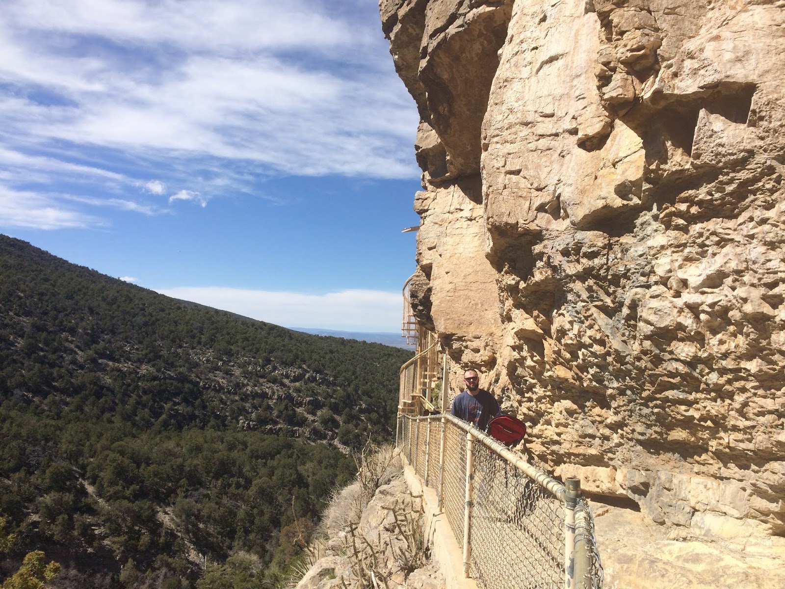
Leslie had been researching trails in the Sandia Mountains and found a short trail that leads to the Sandia Man Cave. The Sandia Man Cave, is an archaeological sitewithin Cibola National Forest. First discovered and excavated in the 1930s, the site exhibits evidence of human use from 9,000 to 11,000 years ago. It was declared a National Historic Landmark in 1961.The Sandia Cave is located on a steep side wall of Las Huertas Canyon, on the north side of the Sandia Mountains. Some of the remains recovered in the cave include mammoth, mastodon, sloth, horses, and ancient camels, as well as many mammal and bird species that survived the end of the Pleistocene period.
We took NM145 nine miles where the pavement ended and an unimproved dirt road began. The first mile, the road was not to bad but the further we went the rougher the road became. Not a problem for our truck, but there were other folks on the road in vehicles without enough ground clearance (including a Minicooper). About two miles in we found the parking lot for the cave trail. There were quite a few people taking the trail. Its only a ½ mile walk one way, but you have to climb several steps of cement stairs, then transition along a narrow ledge cut in the cliff face (don’t look down!) where you come to a metal spiral staircase that climbs up to a metal platform outside the cave. When we got to the spiral staircase, we could see there were a lot of people in the cave, so we waited at the bottom until some of them had made their way down. The stairs and platform are metal grid so a lot of people were having issues with vertigo on them. We made our way up to the cave. There was evidence of numerous fires in the cave (It looked like someone had camped in it recently as well). It was a bit small, and the back of the cave leads into a complex of caves in the cliff, but the back of the cave was blocked by a rock wall to keep people out of the cave complex. Other than that, there was not much to see. After returning to the truck we decided to continue up the dirt road which was called the “Sandia Crest Scenic Byway”. We don’t know much about it being a byway, in fact it was pretty washed out and rutted, but it was scenic! As we climbed in altitude there was even snow on the edges of the road.
 |
| Scenery on the Cave Trail |
 |
| The ledge to the bottom of the spiral staircase |
 |
| The view down the staircase |
 |
| Inside the Sandia Cave |
 |
| Leslie in the cave mouth |
 |
| David in the cave |
Saturday, April 13, 2019
8 April 2019 Salinas Pueblo Missions NM
Since David was going to be working for the next three days, and you never know what the weather is going to do, we decided to snag the last NM in this area today rather than waiting until next weekend. This turned out to be a good choice since it ended up raining/snowing/blowing Friday and Saturday. The drive down to Mountainair New Mexico where the visitor center for Salinas Pueblo Missions National Monument took us across some very wide open prairie. The National Monument actually has four sites (each with their own Passport Stamp) spread out over quite a distance. The main visitor center is located in the town of Mountainair. On our way to the visitor center, we came upon the Abo Pueblo Mission portion of the NM and stopped to see it before the visitor center. Then there are the Quarai Pueblo Mission and Gran Quivira Pueblo Mission (the furthest away from the visitor center). The Spanish explorers arrived in this area in 1582 and noted there was a thriving trade route through the Salinas Valley. There were three large Pueblo villages along the trade route with several thousand Pueblo Indians in the valley. The Spanish Crown decided that New Mexico was never going to be a rich source of gold and treasure and had all but written off the area when the Franciscan Monks convinced the Crown that the Indians needed to be “saved”. The Crown then order the installation of Spanish civil authorities and the Monks sent priest to the valley to convert the Puebloans to Christians. The first Franciscan Priests arrived in the valley in 1618. The Pueblo Indians, who had survived over the centuries by accepting the customs and believes of others, quickly decided to accept the new religion in addition to maintaining their own. The Franciscans conscripted the Indians to build large churches (women were charged with the building of the churches, while the men tended the fields) of the native rock. In the meantime, the appointed civil authorities were also conscripting the Indians to provide goods to be sent back to the Crown. By the 1670s, the tussle between the church and the civil authorities over which was more important for the Indians to be working for, reach a breaking point. In addition, a massive drought hit the area in 1668 to 1674. Crop yield plummeted and the enslaved Pueblo Indians began dying by the hundreds. In addition, the Comanche Indians were raiding the Pueblo villages in retaliation for their part in helping the Spanish in raids on Comanche villages to get slaves. By 1678, all three Pueblos had been abandoned and the survivors moved to the Rio Grande Valley Pueblos. In 1680, the Pueblo Indians rose up and kicked the Spanish out of New Mexico. The Spanish later “re-conquered” New Mexico but the missions and Pueblos were never reoccupied.
We toured the Abo Mission on our way to Mountainair. The church was in pretty good shape but the pueblo buildings were just mounds of dirt. The church was built out of soft rock mined from the near by dry wash. Original wooden beams held up the rock above the windows and doors even after centuries of being exposed to the elements. Interestingly, there was a Kiva built on the church grounds. Kivas were used by the Pueblos for their religious ceremonies. There was a nice paved trail through the ruins and around the mounds where the pueblo structures had once been. We talked with the Ranger on duty at the contact station for quite a while and collected a Passport Stamp (#31) (We will only count the NM as one stamp, not four). We then drove on to the visitor center in Mountainair (interesting little town by the way) we watched the park movie and got our NPS passport stamp.
From the visitor center, we decided that the 40-mile drive to and back for Gran Quivira Pueblo Mission was to far (we are starting to get burned out on Pueblo ruins) and drove to Quarai Pueblo Mission, which was on a route back to Albuquerque. Similar to Abo, the church was in ruins and the pueblo structures have been reduced to just mounds of dirt. The church was built of the same local rock as at Abo. We stopped in the contact station and strolled the paved path around the ruins before heading back to Albuquerque along the Salt Mission Trail Scenic Byway (New Mexico 337). The drive was very scenic as it went through the heart of the Cibola National Forest.
 |
| Entrance Sign |
 |
| Ruins of the Church at Abo |
 |
| A Kiva in the grounds of a Catholic Church? |
 |
| Ruins of the Sanctuary at Abo |
 |
| The Ruins at Abo |
 |
| Visitor Center Entrance Sign |
 |
| The remains of the Sanctuary at Quarai Pueblo Mission |
 |
| Entrance to the Sanctuary at Quarai Pueblo Mission |
 |
| David in the door at Quarai Pueblo Mission |
Monday, April 8, 2019
7 April 2019 Return to Petroglyph NM
After watching church service on Youtube, and getting our Mexican Food Sunday fix, we drove over to Petroglyph National Monument. We had visited Petroglyph National Monument on a previous trip to Albuquerque and hiked the trail by the visitor center. We were not impressed by those petroglyphs. Since we wanted to collect our passport stamp (#30), we decided to try a different trail. After viewing the park film, and talking with the ranger, we settled on the Rinconda Canyon trail. It was a short drive to the trailhead from the visitor center.
The escarpment where the petroglyphs are located is in the Rio Grande Rift. The Rio Grande Rift was formed hundreds of millions or years ago and runs from southern Colorado to Chihuahua Mexico. The Rio Grande river cut through the rift. To the northwest of present day Albuquerque, six volcanoes formed in the rift and release large amounts of lava forming the mesa. The escarpment was created when softer soils under the lava were eroded away causing a shelf that eventually collapsed. The resulting chunks of rock oxidized over centuries giving the rock the black color we see today.
 |
| Entrance Sign |
 |
| Petroglyph |
 |
| Petroglyph |
 |
| Petroglyph |
 |
| Petroglyph |
 |
| Petroglyph |
 |
| Petroglyph |
 |
| Petroglyph |
 |
| Your authors |
6 April 2019 A Twofer!
We got up early this morning to head to western New Mexico. There are two national monuments about 1.5 hours west of Albuquerque. So we decided to go to the farthest one and then work our way east to the second one. The first was El Morro (Spanish for headland) National Park. We arrived around ten and had time to get our 28thPark Passport Stamp, watch the park movie and puruse the park gift shop before heading out on Inscription Rock Trail. El Morro is a fairly small national monument of sand stone that surprisingly shoots straight up from the desert floor where “Inscription Rock” is located. The sandstone formation has a pool of water at its base that was an inviting and reliable oasis and water source. The pool is fed by snow melt and rain water from the butte and faces north so it doesn’t get exposed to the southern sun. Water is always present, even during the worst droughts.
 |
| entrance Sign |
 |
| El Morro |
 |
| The pool at the base of Inscription Rock |
Petroglyphs carved in the sandstone by Zuni Pueblo Indians date back thousands of years. The earliest inscriptions by Europeans were by Spanish explorers in 1605. The earliest English inscriptions were by an Army Officer in 1850 following the area become part of the US after the Mexican American War (1846-1848). Settlers heading to California along the route laid out by Commander Beale stopped at this location as well, leaving their names carved into the rock. One inscription was by a young girl who was later injured in an Indian attack. Another by a Army officer and a Army artist sent to copy the inscriptions in 1859. Some of the inscriptions are getting hard read due to the continuing erosion by rain and wind. There are hundreds of inscriptions spread around the base of the sandstone butte. The trail to the inscriptions is only a half-mile long. Past the inscriptions, the trail continues and climbs to the top of the butte where the remains of a Pueblo village are visible as well as a view down into a box canyon. We decided to skip the butte portion of the trail so we could have more time to visit the other national monument on the way back.
 |
| Petroglyph on Inscription Rock |
 |
| Petroglyph on Inscription Rock |
 |
| Petroglyph on Inscription Rock |
 |
| Inscription on Inscription Rock. Notice the Year |
 |
| Inscription on Inscription Rock. Notice the Year |
 |
| Inscription on Inscription Rock. Notice the Year |
 |
| Inscription on Inscription Rock. Notice the Year |
 |
| Inscription on Inscription Rock. Notice the Year |
 |
| Inscriptions on Inscription Rock. |
 |
| Inscription on Inscription Rock. Notice the Year |
About 30 miles to the east is El Malpais National Monument. We had driven through the northern edge of the monument on the way to El Morro. We noticed there were two RV parks between the two NM that would make good bases for future explorations. While we were at El Morro, we picked up information on El Malpais and the privately run Ice Cave. At the very western edge of El Malpais, there is a dirt/gravel road that runs back to some volcanic cinder cones and lava tubes. The ranger warned us the road was rough, in part due to deep ruts caused by people going on the road when it was wet, and that it was almost impassible when wet. When we got the road, it looked dry and in good shape so we decided to go exploring. The road skirts the western edge of the old lava fields and goes all the way around the western and southern portions of the monument. We took the “Chain of Craters Backcountry Byway” to the Lava Tube loop. We decided to do the Lava Tube loop and then head back to the road since it would take hours to do the entire road. The roads were red dirt with occasional gravel patches and crossed small portions of lava field. We came across many places where we had to navigate around deep ruts from people slogging through deep mud. The Lava Loop road led to a parking area for the giant lava tube trailhead. Having seen plenty of lava and lava tubes in Hawaii on our honeymoon, we decided not to hike the trail. Past the trailhead parking area, the road became very primitive and rough. It tested the ground clearance of the truck in several places. When we finally looped back to the byway, we could see heavy storm clouds building above us. Thinking about the warning of the ranger, we booked it back to the pavement as fast as we could. As we pulled back onto the paved road, it started to rain! Whew!!!
A little way up the road was the Ice Cave. The Ice Cave is a privately owned tourist stop that is grandfathered into the National Monument when it was created in 1906. It has been run by the same family since the late 1800s. From the visitor center, there is a trail to a large lava tube where water had frozen in an ice pool 20 feet thick. The oldest ice at the bottom of the ice pool is 1100 years old. Rainwater and snow melt seeps into lava cave where it freezes in the pool each year. The room with the ice never gets above 31 degrees even when the outside air temperatures are over 100 degrees. Several lava tubes in the monument have ice in them year round. We decided to bypass the Ice Cave since we had spent more time exploring the dirt road than planned and we drove on to El Malpais Visitor center.
The El Malpais visitor center is located immediately off I-40. We collected our 29thPark Passport Stamp, watch the park movie and puruse the park gift shop. The Ranger suggested we drive NM117 down the eastern edge of the NM. It was a beautiful drive. On one side of the road was granite buttes that were 138 million years old. On the other side was a huge lava field dating back thousands of years. The contrast was incredible. At one point the road climbs ontop the granite buttes for an amazing view over the lava fields with the volano cones in the distance. But it was also raining again, so we did not stay too long. Further on there was a granite arch that was amazing. We then headed back to Albuquerque feeling it had been a great day of exploration.
 |
| Entrance Sign |
 |
| View of the lava field from the top of the grant bluffs |
 |
| Granite Arch |
Subscribe to:
Posts (Atom)