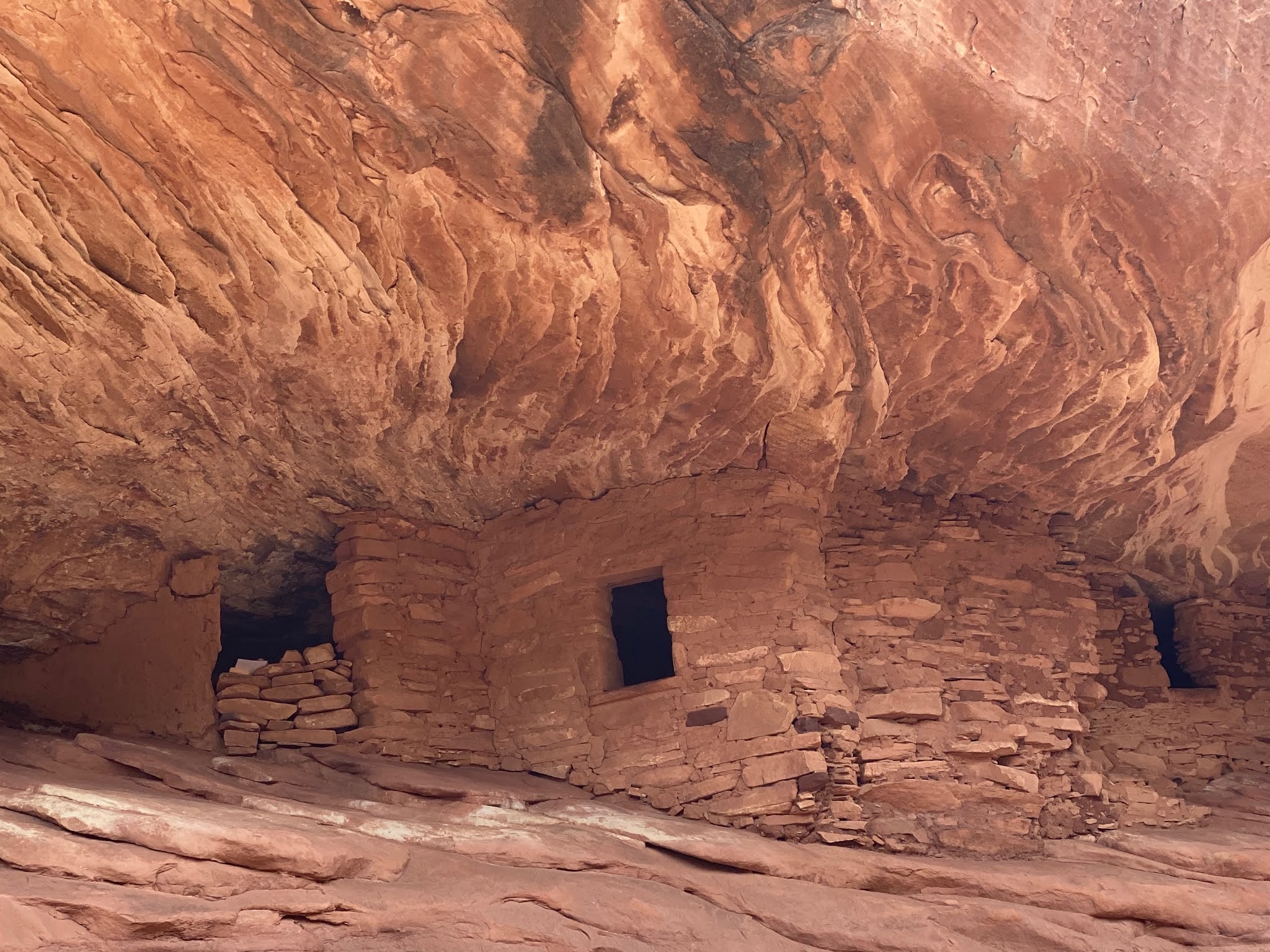
Well, it has been two weeks since our COVID vaccine shots, so we should have some level of immunity now. We had read about the House on Fire ruins in what is now Bears Ears National Monument. It was formerly managed by Bureau of Land Management Indian Creek Recreation area and other parts managed by the National Forest Service. Created by President Obama and then had its boarders reduced by President Trump, the Bears Ears NM has two districts, one encompasses land to the Southeast of Natural Bridges NM and the other encompasses land directly to the east of Canyonlands NP (includes Newspaper Rock). The NM is so new, there is not a visitor center yet, so it is managed by the BLM office in Monticello and the NFS Office in Blanding. We drove the Utah Bicentennial Highway (UT95) to the Mule Canyon turnoff. About a half mile down the road, there were a lot of cars parked on the sides of the road, indicating the trailhead. We went beyond the parked cars and up the hill to find a spot big enough for the Behemoth. The trail to House on Fire is only a couple of miles round trip (2.1 miles, 66 feet elevation gain, 1,066 calories burned). The ruins are in pretty good shape and the striations in the rock ledge above the ruins give the impression of flames coming out of them. Its probably the most visually interesting ruins we have seen so far. There were a lot of people hanging around the ruins, so getting good pictures was a game of patience. Eventually, a lot of the folks left and we had the ruins almost to ourselves and one other couple. We struck up a conversation about camping and hiking experiences and spent a half hour chatting before heading back to the Behemoth.
Our next stop we learned about from a fellow RVer in the RV park. Fry Canyon is a tributary to the huge White Canyon. It intersects UT95 at the minuscule town of Fry. We drove over the canyon on the highway bridge looking for a place to park. We had to turn around and go back to the small rough parking area to the south of the bridge. We had been keeping a close eye on the building rain clouds as we headed toward Fry but the clouds moved off to the east and the sky cleared. Where Fry Canyon goes under the highway, it is a pretty deep slot canyon. We had read that you could access the canyon going north since the canyon directly under the bridge is typically flooded with hip deep brackish water. So we hiked along the eastern rim of the canyon, heading north (Towards White Canyon). We could not find a safe place to descend into the canyon. The walls were 20-30 feet of shear rock. We saw one place on the western edge of the canyon where someone had placed a very rickety, home made, ladder that looked like it was 50 years old and ready to collapse. That was definitely not a safe way down. After going ½ a mile along the rim and not seeing any place to descend, we headed back. When we got back to the parking area, David went further south along a dirt track and found a point where people were obviously descending into the canyon. It was pretty steep slick rock to scramble down, but folks were obviously making it down and back up. But by that point we were ready to head on. We drove a little past the airfield at Fry and took the rough road down to the Fry Canyon Ruins overlook. The ruins were barely visible in the shadows. We could see some folks hiking down in the canyon. As headed back up the road, David dropped the Behemoth into 4 low since we had some rough rock to climb back up. This is only the second time we have ever had to drop the Behemoth into four low to crawl and claw our way. Behemoth handled it with aplomb and we were soon backup on the paved road.
Back on UT95, we continued to head west toward Lake Powell. The drive through huge red cliffs and canyons is beautiful. We saw Jacob’s Chair, a large butte that is shaped like a chair from the right viewpoint. We made it to where the Colorado River flows into Lake Powell only to find no lake! Lake Powell and Lake Mead are at historic low levels. All we found was dry desert where there was supposed to be 40 feet of water. We drove down to Hike where there was supposed to be a marina, boat ramp and camp grounds. The huge concrete boat ramp was dry as a bone with no water in sight. The marina was closed and the campgrounds were empty. That pretty much canceled our thoughts of renting a houseboat on Lake Powell for a week. It was getting late, so we headed back on the 2 hour drive to the Wanderer and Etta.
 |
| House on Fire |
 |
| House on Fire |
 |
| Selfie |
 |
| Fry Canyon |
 |
| Fry Canyon Ruins |
 |
| Scenery on Bicentennial Highway |
 |
| Boat Ramp at Lake Powell |
 |
| Lake bed at Lake Powell (This should be 20 feet underwater) |
 |
| Views fro Bicentennial Highway |
 |
| Jacob's Chair |


No comments:
Post a Comment