Friday, April 5, 2019
5 April 2019 Santa Fe to Albuquerque
We moved from Santa Fe to Albuqeurque to prepare for David’s meetings next week. Were staying at the American RV Resort ($41 per night with GSC discount) on the western edge of town. We stayed here back in 2017. It does not look like they have changed much other than their WiFi provider (Now TenGoInternet). We got here fairly early since the drive down was short. So after setting up we drove down to Old Town and had lunch at Church Street Café. On the way back we took the old Route 66 and noticed the Rio Grande was full of water and flowing quite swiftly. This is a big contrast to the dry river bed we saw in Las Cruces. We have four National Monuments to visit during our stay here. Two out West are pretty close together, one here in town and one to the southeast .

4 April 2019 Kasha-Katuwe Tent Rocks National Monument
After our aborted attempt Wednesday to see Kasha-Katuwe Tent Rocks National Monument, we decided to give it another shot today (Kasha-Katuwe means “white rock” in the local Pueblo language). As soon as David wrapped up his work, we drove out to the NM. Its only a 20 minute drive from Santa Fe. This is the nicest BLM NM we have been to so far. The facilities at the trail head were very nice. We arrived at 2:45 and were told the Rangers started clearing the trails at 3:30. The basic geology of the area is Volcanic Tuff with a cap of lava for the 20 or so volcanoes in the area 2-3 million years ago. As the tuff erodes due to weather, some parts are protected by the solidified lava, others not so much. The Tent Rocks are formed by a piece of overlaying solidified lava protecting the tuff below it from erosion while the surrounding tuff is washed away.
We decided to do the slot canyon trail (1.5 miles). It was a really fun hike. There were spots where we had to turn sideways to squeeze through and other places where we had to crawl under boulders or fallen trees! The trail continued through the slot canyon and climbed up to an over look. David made it to 100 feet of the overlook when the Rangers stopped him and sent him back down the trail (Drats!) as they began clearing the trails. So we worked our way back down the canyon hoping to make the junction with the cave trail and then do the cave trail. Unfortunately when we got to the trail junction they had already closed the cave trail so all we could do is head home. We will need to come back to this BLM NM on our next visit.
 |
| Entrance Sign |
 |
| Entrance to the narrows |
 |
| Leslie in the narrows |
 |
| Tent Rocks |
 |
| More tent rocks |
 |
| Looking down into the canyon |
 |
| A tree root crossing the trail |
 |
| Low headroom! |
 |
| The Narrows |
 |
| Tree roots! |
 |
| David at the entrance to the Narrows |
 |
| Tent Rocks |
 |
| Tent Rocks |
 |
| Osprey Nest |
Monday, April 1, 2019
30 March 2019 Fort Union National Monument
With a winter storm scheduled to come in tonight, we decided to squeeze one more National Monument in before it hit. We drove the 1.5 hours to Fort Union National Monument in cold but beautiful sunny weather. We arrived at Fort Union to find the wind blowing at 15-20 MPH across wide open plains, which dropped the wind chill down into the 20s. The park allows you to bring dogs on the trails so we brought Etta along for the adventure.
The first Fort Union was built in 1851, following the end of the Mexican American War (1846-1848), to secure the new southwestern territories of the United States. The site was chosen because the two branchs of the Santa Fe Trail (Mountain Trail and Cimmaron Trail) come back together just east of this site and ran just past the fort. Ruts from the thousands of wagons that traveled the Santa Fe Trail through the fort are easily visible. The first fort was built by the soldiers using green trees that had been felled from the surrounding hills. They nestled it up against a tall bluff to shelter the fort from the constantly blowing western winds. The calvery waged several campains against the indians from 1851 to 1861. In addition, the fort was the main supply house for the forts built further west with thousands of wagon loads of essentail gear coming into the fort from the Santa Fe trail before being distributed further west. We arrived around noon and had time to get our 27thPark Passport Stamp, watch the park movie and puruse the park gift shop before receiving a guided tour by a Park Ranger. He was very informative and did not mind us taking Etta along for the 45 minute foot tour of the fort grounds. We were the only ones on the tour. The cold wind was a bit uncomfortable and we were happy to jump in the truck after the tour to warm up! Even Etta was cold!
Following the outbreak of the Civil War in 1861, a good portion of the forts professional army garrison was sent back east to join the Union Army. The fort was garrisoned with Union volunteers from New Mexico and Colorado. The old fort was falling apart due to poor materials and shoddy construction. It was also realized that being at the base of a bluff was a poor defensive postion. With word that the Confederate forces from western Texas were marching on Alburquerque and Santa Fe, a new fort with tall dirt balstrays in a star pattern with cannon positions was built further out on the grassy plains and all the troops were moved in behinds its dirt walls. The fort was never attacked. Following the defeat of Confederate Forces by the fort’s garrison and additional Colorado and New Mexico Volunteers at Apache Canyon just to the west of the fort, in 1862, the Civil War came to an end in the South West. The Confederates retreated back into West Texas. The conditions in the dirt fort were terrible and it was decided to build a new Fort Union. Construction began in late 1862. This time it was built by local construction civilians out of brick, stone and Adobe, the remains of which we see today. Fort Union remained a major supply depot until the coming of the railroad in the late 1870s. Additional campaigns were waged from the fort against the plains Indians through the early 1880s. The Fort was final abandoned in 1891. The Fort’s hospital was the only hospital for over 500 miles and served the Fort garrison and the local civilian population (although civilians had to pay 50 cents a day to stay there) and people traveling on the Santa Fe Trail. It had 126 beds, two Army Doctors, a couple of Nurses and assistants which would serve around 400 patients a month. At its hayday, the forts population was over 1500 soldiers and civilians including Kit Carson.
On the drive home we drove through snow showers of the leading edge of the incoming storm.
 |
| Fort Union Entrance Sign |
 |
| Officers Row |
 |
| Rank had its privileges |
 |
| Remnants of Officers Quarters |
 |
| The Military Jail |
 |
| Ruins of the hospital |
Friday, March 29, 2019
29 March 2019 Bandelier National Monument
Given the forcast for great temperatures but high winds, we decided a canyon hike would be appropriate to help block the wind. We drove the hour to the main Visitor Center for Bandelier NM. In the summer, the main Visitor Center is not accessible, you must stop at the White Visitor Center and take a bus into the canyon. We watched the park film and collected our 26thPark Passport stamp.
We hiked the main loop trail (approximately 1.2 miles) which takes you past a very large kiva, then to the Tyuonyi Pueblo and then to the dwellings carved or built up against the cliff walls. There was also quite a few petroglyphs in the cliff walls. At the halfway point, we took the trail to the Alcove room (and additional half mile each way). We crossed the stream multiple times on the way to the room. The canyon experienced two bad forest fires in 2011 and 2013 followed by multiple flash floods which washed many dead trees down the canyon causing these huge stacks of logs and debris that had to be clear from the trail. The stream was running pretty fast due to snow melt. When we got to the Alcove room, we could see that there were multiple wooden ladders that had to be climbed along with some stone steps climbing 14 stories up the canyon wall. Leslie took one look and decided her knee would not take it. David proceeded on up the ladders to the alcove. There really was not much there. A kiva that was built in 1908 and a couple of small rooms cut into the cliff face. So the real thrill was climbing up and down the tall ladders.
Following our hike we went to the Second Street Brewery in Santa Fe for some beer and dinner. I can’t believe we had not found this place in our previous trips to Santa Fe, but we will definietly be back!
 |
| Entrance Sign |
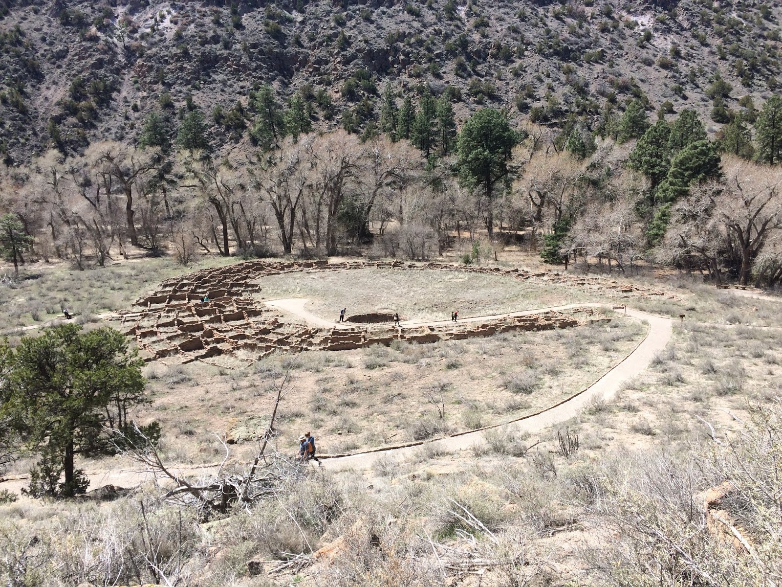 |
| Tyuonyi Pueblo |
 |
| Leslie looking out of one of the caves |
 |
| Cave Dwellings |
 |
| Cave Dwellings |
 |
| petroglyphs |
 |
| petroglyphs |
 |
| Ladder #1 |
 |
| Ladder #2 |
 |
| Ladder #3 |
 |
| The Alcove |
27 March 2019 Las Cruces to Santa Fe New Mexico
We moved from Las Cruces to Santa Fe. The weather was warm, low 80s, and the trip was mostly up hill, so the truck was running a little warm, but nothing too bad. We are staying at Santa Fe Skies (53.25 per night with GSC Discount), the same park we stayed at back in September 2017. They have made improvements since our last visit (new patios, upgrade landscaping, new sculptures) and it looks good. In the distance we could see quite a bit of snow in the mountains. It makes us wish we had brought our ski gear along since the local ski resorts are still open. There are three National Monuments (two NPS and one BLM) that we plan to visit while we are here.
 |
| Sunset |
 |
| Our Patio |
 |
| Desert Art |
Tuesday, March 26, 2019
25 March 2019 A Hike in the Trees
Feeling the need to stretch our legs some more, we returned to Organ Mountains – Desert Peaks NM. But this time we hiked on the east side of the mountains in the Aguirre Springs Wilderness Area. We selected the Pine Tree loop trail (4 miles) which took us through a high desert environment before transitioning into a high Alpine type of Ecological zone. Our research on the trail indicated most people hiked the loop counter-clockwise because it made the up hill portion a bit less steep since the climb is spread over more distance. But we hiked it clockwise. Not because we really wanted to, but because from where we started, we completely missed the turn to go in counter clockwise direction. In the end, we were happy we did it clockwise. Some of the stuff we had to climb up we would not have wanted to have to go down. So it worked out well. The views of the rocky peaks of the Organ Mountans were spectacular as well as the view looking out over the White Sands Basin. Looking into the basin we had very good views of White Sands Missile Range Army Base as well as White Sands NM. Our critter sightings were finches, doves, beatles and one lizard. The altitude (6000-6900 feet) defintely took its toll, but so did the steep climbs and long decent. By the time we got back to the truck we were ready for a cold brew and a green chile cheese burger! So we made a bee line for the High Desert Brewery!
 |
| Trailhead |
 |
| Only halfway? Really? |
 |
| Organ Mountain Spires |
 |
| White Sands Basin |
 |
| The wild flowers were spectacular |
 |
| Organ Mountain Spires |
 |
| The Spires backlight by the setting sun |
Saturday, March 23, 2019
23 March 2019 Gila Cliff Dwellings National Monument
We got up early this morning for the 3.5 hour drive to Gila Cliff Dwelling National Monument in western New Mexico. Its really not that far from where we are parked in Las Cruces, but the roads to the NM, through Gila National Forest, are narrow, twisty, windy, steep mountain roads. We went in through Silver City on the Mountain Trail National Scenic Byway and returned through Hatch via Geronimo Trail National Scenic Byway which connected to New Mexico Back Country Scenic Byway. The road to Hannah in Hawaii has nothing on these roads and the scenery was pretty awesome! We stopped at the Visitor Center, collected our 25thPark Passport Stamp, viewed the exhibits and watched the Park movie. We then drove to the trailhead.
The mountains around the monument were formed by two super volcanoes that blew 28 to 30 million years ago. The rock formations are a combination of soft volcanic tuft and harder lava flows. The cliff dwellings were built by the Mogollen Puebloan Indians between 1276 and 1287 based on treee ring dating of the wood used in the buildings. They did not stay long. Scientist believe the Mogollens had moved on by 1300. The Cliff Dwellings were made a NM by President Roosevelt in 1907 but by then the caves had already been looted of most of their archilogical treasures. There are 40 rooms with many of them accessible from the trails. We left Etta in the supplied dog kennels and hiked the Cliff Dwellings Trail (1 mile) and explored the ruins for about an hour. We looked for, but did not see any, Pictographs that were supposed to be in the main room. But we saw lots of grafitti from the early days of the NM. The only critter sighting was a lizard from the trail.
This used to be the hardest National Monument in the country to reach. In the 1910/20s they had to organize caravans of automobiles over dirt roads to help folks reach the NM due to its remoteness and rugged road conditions.
 |
| Entrance Sign |
 |
| Cliff Dwellings from the lower trail |
 |
| Cave 2 Dwellings |
 |
| Leslie in the main cave |
 |
| Main room |
 |
| Lower walkway |
 |
| The exit ladder |
 |
| View from Emory Overlook |
Subscribe to:
Posts (Atom)