After waiting to hear from any of the glass shops in Kalispell, we learned that none of them were open on the weekend. So we bought some duct tape and plastic and covered the rear window and headed down the road since we knew we would be in Spokane by Monday and we would have a better chance to get it fixed there. The plastic flapped loudly when we were in the cross wind (which was most of the time) and we had a new appreciation of how important the rear window is for cutting down noise! The drive was uneventful. We have become used to the climbs in the mountains and watching the temperature gauges. We are staying in Blue Anchor RV Park ($40 per night with GSC discount) in Osborn Idaho. It’s a small, old, rundown RV park. Over half the spots are taken up with old run down single wides or old RVs held together with duct tape. The streets are narrow and we had fun maneuvering into our pull through site. But the utilities were good and the WiFi was strong and fast.
Monday, July 29, 2019

26 July 2019 Final Day in Glacier
Leslie seemed to be over her cold so we decided to try and get some more things in Glacier accomplished. One was to hike the Hidden lake trail. We heard the views were gorgeous and there have been a lot of animal sights from this trail. The trail starts at the Logan Pass Visitor Center and we had been advised we needed to be there by 9am to get a parking space. We also wanted to kayak in a glacier fed lake in the park. We would need to get the kayaks inspected for “contaminants” (Zebra Mussel) before we could put in. We also wanted one last lunch at Lake McDonald Lodge. So we loaded up the kayaks on the new wooden standoffs over the bed of the truck, got up early and headed up the Going-to-the-Sun road to Logan Pass. We arrived just before 9am to find the parking lot already full. We circled around the parking lot, along with dozens of other cars, for 45 minutes hoping to get lucky and have someone back out in front of us and that the parking spot would be big enough for the behemoth. We were not lucky. So we headed back down the Going-to-the-Sun Road. The majority of the traffic was headed up toward the pass, so we kept having to stop because the oncoming traffic was not leaving enough room for the Behemoth to squeeze between them and the rock wall since they were hugging the center line. We kept thinking of what Amy, our Red Bus driver and said about how they had a evening patrol that would go down the Going-to-the-Sun road to clean up the broken plastic and glass from cars that hit the wall or slapped mirrors as they pass oncoming traffic.
We made it down without incident and stopped at Lake McDonald Lodge. The lounge was not open for lunch yet so we hung out on the back porch of the lodge and people watched. Following another delicious lunch, we headed for Apgar Village to get the kayaks inspected. After passing the inspection and changing cloths, we headed for the nearby picnic area to launch. Once on the water of Lake McDonald it was just magical. Gliding through a glacier fed lake, in beautiful clear water (we could see the bottom 30 feet down and fish swimming by), with the mountains (snow still on the tops) and glaciers around you was amazing! It was so relaxing and calm. We kayaked for two hours before heading back to shore. After loading up the kayaks we headed back to Hungry Horse. It was with great reluctance that we passed through the exit of Glacier National Park. We could feel it calling us back!
 |
| Kayaking on Lake McDonald in Glacier NP |
We went into Columbia Falls and took care of some tasks to get ready to pull out in the morning (Washed the truck and kayaks, grocery shopping, fill up on fuel) and headed back to the Wanderer. David backed in to line up the Behemoth with the hitch to make it easier to hook up in the morning when there was a LOUD CRASH!. The rear window on the Behemoth had shattered into a thousand pieces and the kayaks were poking into the rear seats. David had forgotten the back of the kayaks extend a couple feet beyond the back of the truck and they hit the nose cap of the Wander and pushed into the rear window. CRAP!!!! It was after 5 on a Friday Night in small town USA. After checking the window damage, and determining the Wander and kayaks were undamaged, we tried to call the local glass shops and got voice mail. We left messages and hoped one of them would be open on Saturday. Meantime we checked with the RV Park to see if we would be able to stay longer. The site we were in was booked for the weekend. But the spot directly in front of us was open since they had left it open for us to pull through when we left Saturday. So we booked it for Saturday nigh and hoped we could get the window repaired on Saturday in Kalispell. Then we cleaned up glass.
 |
| Kayak Torpedoes |
Monday, July 22, 2019
20 July 2019 Red Bus
We took a tour ($56 per person) on the famous Glacier Red Bus today. Buses in Glacier have been running since 1914. The famous Red Buses were built in 1935-36. The government ordered 300 buses from the White Bus company for $500 a piece. Glacier received 35 of these buses (Yellowstone had 100 Yellow Buses but sold them all off over the years and are trying to buy them back now) of which 33 are still in service. One is a museum piece and one crashed. By 1999, the buses were getting to be a safety hazard and were taken out of service. Ford Motor Company offered to refurbish the buses and took the 34 that had been used in service, removed all the coach work from the frames and rebuilt the coach work onto a Ford F-450E commercial truck frame. The cost to Ford of refurbishing the buses was $250,000 a piece. They were then donated to the National Park Service. The buses are run by a concessioner for the NPS. The drivers are known as Jammers for when they had to “jam” the manual transmission gears. Our driver, Amy, had been driving the buses over the Going-to-the-Sun Road for 4 years. The morning was a bit cool (45 degrees), so we started out with the fabric top on, but before we started the climb up the Garden Wall, we pulled over and David helped fold the top back. It was a bit breezy and the blankets were quickly pulled out to cover our knees. When you were in the sun, it was pretty comfortable. Amy kept up a constant monologue all the way up to Logan’s Pass. But we learned some things from her speech. One thing that caught David’s attention was the reason why the guard rail in some locations was the original rock walls from the CCC and in other places there was steel reinforced log rails instead. They have been rebuilding the Going-to-the-Sun Road for the last three years as part of a multimillion dollar project. There are places where avalanches had wiped out the original CCC built walls repeatedly over the decades. So in those places, they have installed removable steel reinforced log rails. Every year the park service unbolts the log rails and moves them against the cliff face for the winter so the avalanches can roll through and not damage them. Every spring, they spend two months clearing the snow and avalanche debris from the road and bolt the log rails in place. This year the road opened on 22 June, a bit late, due to a late season avalanche that spread over the road and had to be cleared. This year they will close the road on 15 September so they can finish the rebuilding project. They normally keep it open until the first snow, which is typically in early October.
The views of the mountain from the Red Bus were incredible. Much better than when we drove it since we did not have to worry about driving (Amy had a few choice words about the people driving) and could enjoy the views from the open top bus. We even got to see some Big Horn Mountain goats! This is definitely the way to see the Going-to-the-Sun Road!
 |
| Sacred Dancing falls |
 |
| Leslie and David at Sacred Dancing Falls |
 |
| View from Logan Pass |
 |
| Logan Pass International Peace Park |
 |
| Red Rocks |
 |
| Garden Wall that the Going-to-the-Sun runs along |
19 July 2019 Take Your Medicine
Still trying to avoid the crowded parts of the park, we decided to drive over to the southeastern portion of the park at Two Medicine Lake. The weather sounded familiar, 20% chance of rain, but we hoped it would hold off today. Leslie drove us to the Two Medicine Parking lot. It was almost full when we got there about 11am. We had just missed the 11am excursion boat to the end of the lake and the next one was not until 1pm. So we decided to hike the shoreline trail. We started off on the south shore portion of the loop trail. The weather was sunny, but a little windy and cool. So we had our coats on at first until we worked up a sweat. We took the side trail to Astor Falls, a pretty little multi-tiered waterfall, before continuing up the south shore trail. We were about 2/3rdof the way up the south shore of Two Medicine Lake when we began to hear thunder. But we were in the trees and could not see where it was coming from. When we finally came to a meadow, we could see black boiling clouds coming over the ridge in front of us and down into the canyon where Twin Falls was located, our destination. Two other couples were standing there looking at the clouds when there was a loud rumble of thunder. We all decided at the same time that we best beat a retreat. As we quick stepped back toward the trailhead we started getting pelted by sleet and big drops of rain. So we quickly pulled on our coats and hurried on down the trail. Then it turned to frozen rain and began to cover the ground. After about 15 minutes it let up and the sun came out. By that time we were most of the way back to the trailhead, cold and wet from the waist down. But the sun warmed us up and clouds disappeared over another ridge and it was turning back into a beautiful day. We stopped and discussed maybe turning back to continue our hike, but that would have been an extra 2 miles to the 8 mile hike. So we continued back toward the trailhead but decided to take the side trail to Paradise Point. When we got to the point, which juts out into Two Medicine Lake, the wind almost knocked us off our feet, and looking up the lake we could see a new batch of severe thunderstorms boiling over the ridge dropping hail like a vengeance. That was the final straw, we booked for the trailhead and managed to get there before the worst of the weather hit us. We have decided that 20% chance of rain in Montana really means 100% chance of rain!
We stopped on the drive back at the Glacier Park Lodge. Built in 1915 by the Northern Pacific Railroad, the lodge features vertical wooden columns three stories high made from 800 year old redwood trees imported from the Pacific Northwest. The lodge is just gorgeous! So of coarse we had to stop in the lounge for an early dinner and a couple of drinks to help warm us up!
 |
| Bever Pond |
 |
| Astor Falls |
 |
| Glacier Park Lodge (Check out the solid wood columns) |
 |
| Two Medicine Lake from Paradise Point |
17 July 2019 Kintla Lake
Having endured the crowds for the last several days, we decided to head for the far northwestern portion of the park again. Weather forecast was for 20% chance of rain. Leslie drove us on the way out, her longest off pavement experience to date. We followed the Camas Road to the North Fork road where it turned to gravel. Stayed on that to Polebridge where we followed the primitive dirt road back into the park. By the time we reached the park entrance, it was a constant drizzling rain, making the dirt road a little slick. When we got to the park gate, the Ranger warned us the parking lot at Kintla lake was already full. But we decided to drive it anyway and hope that someone had left before we got there. The road was not too bad, a lot of pot holes to maneuver around and several stretches of washboard, and having to deal with vehicles coming out from Kintla Lake with very little room on the one lane road for passing. Once we arrived at Kintla Lake, we were able to find a parking spot. We had planned to hike the Kintla Lake Trail, but by the time we arrived, it was a pouring rain that did not show any signs of letting up. We put on our raincoats (need to start carrying our rain pants with us in the truck) and walked around the small campground and over to the Ranger Station before deciding it was not going to stop raining and headed back. David drove back since Leslie had enough of off pavement driving. We stopped at the saloon in Polebridge to enjoy a couple of beers, talk with the locals and of course pick up some more Huckleberry Bear Claws at the fabulous bakery!
 |
| Kinta Lake |
 |
| Saloon in Polebridge |
Tuesday, July 16, 2019
15 July 2019 Avalanche Lake
Having learned our lesson, we set an alarm for this morning and arrived at the parking for Avalanche Lake Trailhead around 8:15. We quickly found a parking spot for the Behemoth and gathered ourselves up for the hike to Avalanche Lake. It was cool enough that we needed our coats starting out but quickly shed them on the climb up. We started out hiking one side of the Trail of the Cedars to the trailhead for Avalanche Lake trail (we took the other half of the loop on the way back). The walk through the giant western cedar trees, hemlock trees and black cotton wood trees made you feel tiny and humble. They have been there for up to a thousand years. Incredible.
The trail to Avalanche Lake (6.9 miles including Trail of the Cedars, 827 feet of elevation gain, 1,808 calories) starts at the opposite end of the Trail of Cedars loop and continues through a forest of cedar and hemlock. The first part of the trail climbs up along side a 200 foot canyon with a stream thundering through it. The trail continues to climb but veers off from the stream and into the forest. This trail is very popular, so there are lots of people heading up this trail and even a few on the way back already. It got to the point where we got tired of greeting people! About two thirds of the way to the lake, we came across an area in the trail where the trees had obviously been knocked down from an avalanche from the cliffs above. From the different ages of the fallen trees, it was obvious that this area had been hit by multiple avalanches over the years. A little farther down the trail we came on a deer grazing along side the trail, our first critter sighting after being in the park for three days. We arrived at Avalanche Lake and it took our breath away with its beauty. There were three waterfalls at the far end feeding the lake. Each of the waterfalls was several hundred feet high. We took lots of pictures and sat down to drink some water, have a snack, and absorb. But the beach where we were was quickly becoming filled with hikers. Having read on line reviews, we knew most people stopped as soon as they came to the lake. So we continued around the rim of the lake to another beach that gave closer views of the waterfalls. We then continued all the way to the end of trail marker where we were dumped into a swift flowing stream. Not wanting to hike back with wet feet, we turned back. But we did notice where some folks had bush wacked past the end of trail sign, but were not feeling adventurous to see where it led. We took our time hiking back, absorbing the cool air, cedar scent and the feeling of calm. As we hiked back, the quantity of people hiking up the trail kept continuing to increase. Whole busloads of folks were walking up in large groups. Even so, we were reluctant to complete the hike. This was one of the best trails Leslie and I have ever hiked. Absolutely beautiful.
 |
| Trail of the Cedars |
 |
| Creek running along the trail |
 |
| Avalanche Trail |
 |
| Avalanche area |
 |
| Deer along the trail |
 |
| Avalanche Lake |
 |
| Avalanche Lake |
14 July 2019 Best Laid Plans
We had several people tell us that Avalanche Lake trail was a must do trail in the park. We also knew that it was a popular hike. So we planned on getting up and moving this morning so we could be at the trailhead parking lot earlyish. But we did not set an alarm, counting on waking up at our usual 8 am. So, we actually woke up around 10 am (We know, rough life huh?). So we did not get to the parking lot off the Going-to-the-Sun Road until almost noon. We hoped we would catch someone pulling out after completing their hike. And sure enough, there were people doing just that, but the car in front of us always got the spot! After two trips around the various parking cubbyholes at the trailhead (There is not a large parking lot parsee), we gave up. Our timing was not right to get a spot. So coming up with a plan B, we decided to continue heading up the Going-to-the-Sun Road to the trailhead for Hidden Lake. Guiding the Behemoth over the narrow roadway (the Behemoth takes up more than its fair share of a lane), with rock guard rails or solid rock cliff walls on one side, and oncoming traffic squeezing against the center line because they were afraid of the rock on their side, was an experience. David managed to not clip rock or hit any oncoming vehicles, although it seemed we came within an inch more than once! Most of the pull offs were full of cars as we drove up but were able to stop at three or four for pictures.
 |
| Bird Woman Falls |
 |
| View from Logan Pass Visitor Center |
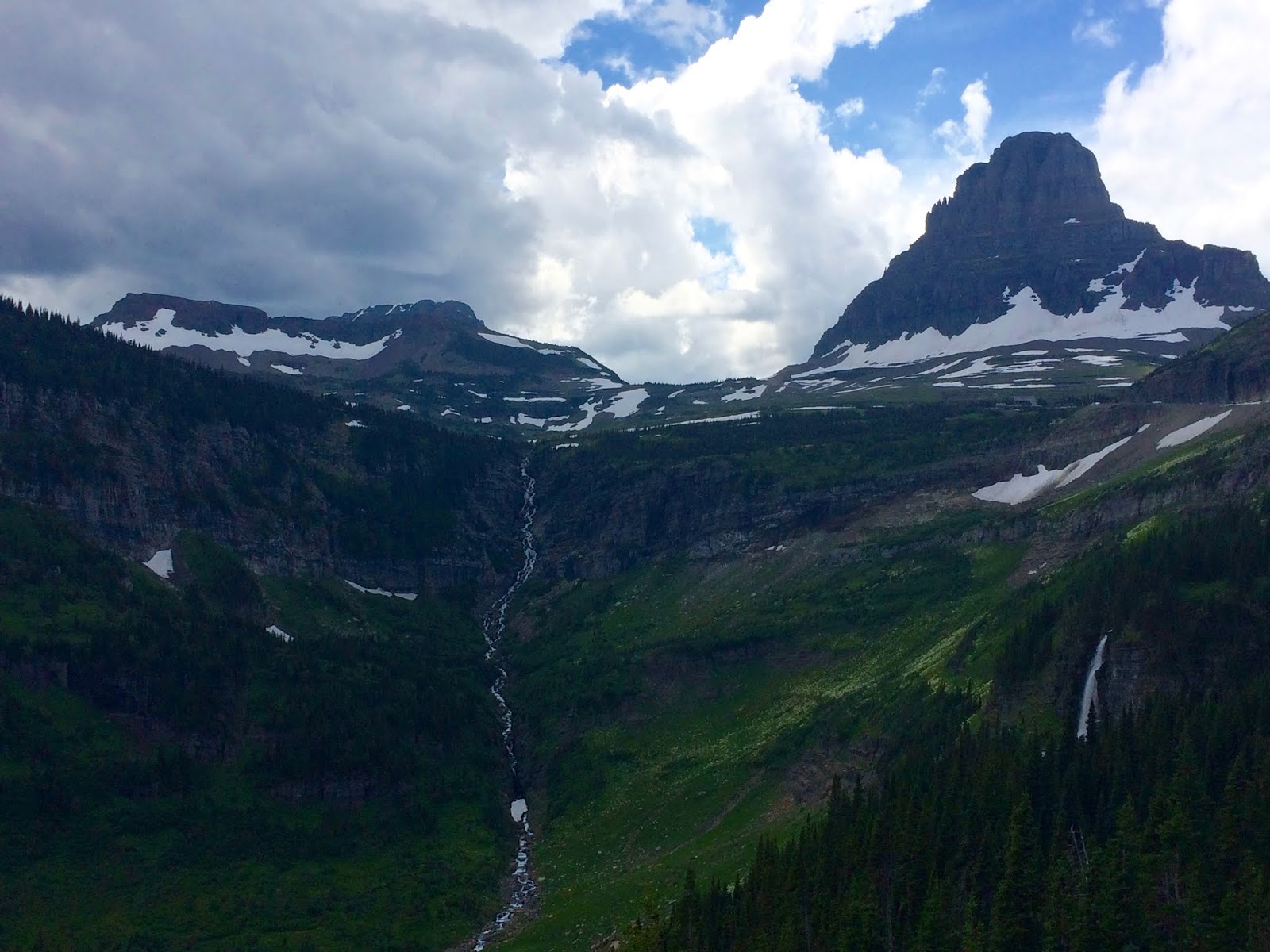 |
| View from Going-to-the-Sun Road |
 |
| View from Going-to-the-Sun Ro |
 |
| Going-to-the-Sun Road |
 |
| View from Going-to-the-Sun Ro |
 |
| Jack Glacier |
 |
| Lake St Mary |
Subscribe to:
Posts (Atom)